You are here: Home > Network List > TA - USArray Transportable Network (new EarthScope stations) Stations List
> Station Q20K Shuyak Island, AK, USA > Earthquake Result Viewer
Q20K Shuyak Island, AK, USA - Earthquake Result Viewer
| Earthquake location: |
Mindanao, Philippines |
| Earthquake latitude/longitude: |
9.8/126.5 |
| Earthquake time(UTC): |
2019/02/08 (039) 11:55:08 GMT |
| Earthquake Depth: |
25 km |
| Earthquake Magnitude: |
5.9 Mww |
| Earthquake Catalog/Contributor: |
NEIC PDE/us |
|
| Network: |
TA USArray Transportable Network (new EarthScope stations) |
| Station: |
Q20K Shuyak Island, AK, USA |
| Lat/Lon: |
58.61 N/152.39 W |
| Elevation: |
180 m |
|
| Distance: |
77.0 deg |
| Az: |
32.048 deg |
| Baz: |
267.561 deg |
| Ray Param: |
0.050573226 |
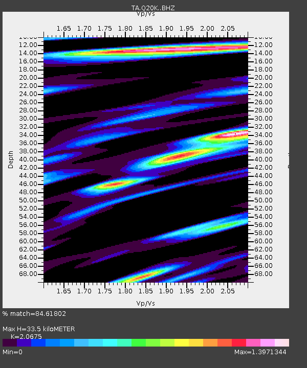
| Estimated Moho Depth: |
33.5 km |
| Estimated Crust Vp/Vs: |
2.07 |
| Assumed Crust Vp: |
5.989 km/s |
| Estimated Crust Vs: |
2.897 km/s |
| Estimated Crust Poisson's Ratio: |
0.35 |
|
| Radial Match: |
84.61802 % |
| Radial Bump: |
400 |
| Transverse Match: |
66.036835 % |
| Transverse Bump: |
400 |
| SOD ConfigId: |
13570011 |
| Insert Time: |
2019-05-02 12:39:49.623 +0000 |
| GWidth: |
2.5 |
| Max Bumps: |
400 |
| Tol: |
0.001 |
|

Signal To Noise
| Channel | StoN | STA | LTA |
| TA:Q20K: :BHZ:20190208T12:06:27.875005Z | 2.811229 | 1.1414583E-6 | 4.0603533E-7 |
| TA:Q20K: :BHN:20190208T12:06:27.875005Z | 1.3282503 | 5.229776E-7 | 3.9373424E-7 |
| TA:Q20K: :BHE:20190208T12:06:27.875005Z | 1.5906945 | 5.4006205E-7 | 3.3951335E-7 |
| Arrivals |
| Ps | 6.1 SECOND |
| PpPs | 17 SECOND |
| PsPs/PpSs | 23 SECOND |


