You are here: Home > Network List > TA - USArray Transportable Network (new EarthScope stations) Stations List
> Station S26A Kim, CO, USA > Earthquake Result Viewer
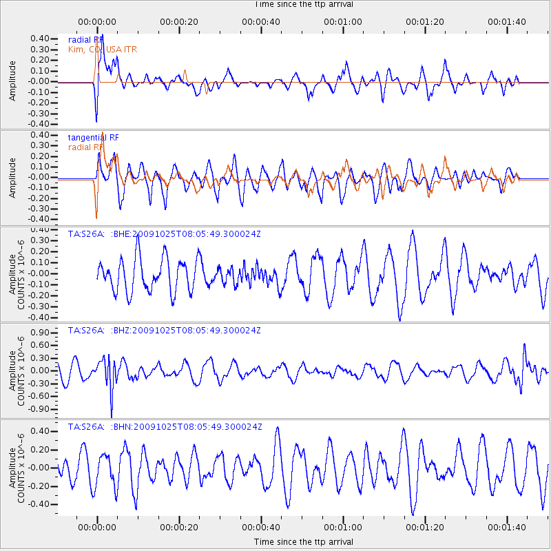
S26A Kim, CO, USA - Earthquake Result Viewer
*The percent match for this event was below the threshold and hence no stack was calculated.
| Earthquake location: |
South Of Fiji Islands |
| Earthquake latitude/longitude: |
-23.1/-179.2 |
| Earthquake time(UTC): |
2009/10/25 (298) 07:53:52 GMT |
| Earthquake Depth: |
418 km |
| Earthquake Magnitude: |
5.6 MB, 6.0 MW, 5.9 MW |
| Earthquake Catalog/Contributor: |
WHDF/NEIC |
|
| Network: |
TA USArray Transportable Network (new EarthScope stations) |
| Station: |
S26A Kim, CO, USA |
| Lat/Lon: |
37.62 N/103.47 W |
| Elevation: |
1394 m |
|
| Distance: |
93.3 deg |
| Az: |
50.426 deg |
| Baz: |
243.365 deg |
| Ray Param: |
$rayparam |
*The percent match for this event was below the threshold and hence was not used in the summary stack. |
|
| Radial Match: |
58.330444 % |
| Radial Bump: |
400 |
| Transverse Match: |
59.396843 % |
| Transverse Bump: |
400 |
| SOD ConfigId: |
2622 |
| Insert Time: |
2010-03-06 20:03:57.245 +0000 |
| GWidth: |
2.5 |
| Max Bumps: |
400 |
| Tol: |
0.001 |
|
Signal To Noise
| Channel | StoN | STA | LTA |
| TA:S26A: :BHZ:20091025T08:05:49.300024Z | 1.8304158 | 3.4795596E-7 | 1.9009666E-7 |
| TA:S26A: :BHN:20091025T08:05:49.300024Z | 1.2663485 | 1.8077037E-7 | 1.4274931E-7 |
| TA:S26A: :BHE:20091025T08:05:49.300024Z | 0.45048082 | 6.652248E-8 | 1.4766997E-7 |
| Arrivals |
| Ps | |
| PpPs | |
| PsPs/PpSs | |


