You are here: Home > Network List > TA - USArray Transportable Network (new EarthScope stations) Stations List
> Station S26A Kim, CO, USA > Earthquake Result Viewer
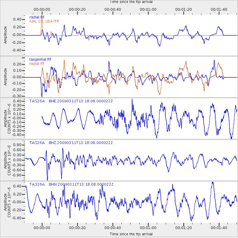
S26A Kim, CO, USA - Earthquake Result Viewer
*The percent match for this event was below the threshold and hence no stack was calculated.
| Earthquake location: |
San Juan Province, Argentina |
| Earthquake latitude/longitude: |
-31.9/-69.2 |
| Earthquake time(UTC): |
2009/03/11 (070) 13:06:53 GMT |
| Earthquake Depth: |
28 km |
| Earthquake Magnitude: |
5.5 MB, 4.8 MS, 5.3 MW, 5.5 ML |
| Earthquake Catalog/Contributor: |
WHDF/NEIC |
|
| Network: |
TA USArray Transportable Network (new EarthScope stations) |
| Station: |
S26A Kim, CO, USA |
| Lat/Lon: |
37.62 N/103.47 W |
| Elevation: |
1394 m |
|
| Distance: |
76.2 deg |
| Az: |
332.577 deg |
| Baz: |
150.434 deg |
| Ray Param: |
$rayparam |
*The percent match for this event was below the threshold and hence was not used in the summary stack. |
|
| Radial Match: |
69.28768 % |
| Radial Bump: |
400 |
| Transverse Match: |
72.224174 % |
| Transverse Bump: |
386 |
| SOD ConfigId: |
2658 |
| Insert Time: |
2010-03-06 20:04:07.001 +0000 |
| GWidth: |
2.5 |
| Max Bumps: |
400 |
| Tol: |
0.001 |
|
Signal To Noise
| Channel | StoN | STA | LTA |
| TA:S26A: :BHZ:20090311T13:18:08.000022Z | 2.81101 | 3.9398324E-7 | 1.401572E-7 |
| TA:S26A: :BHN:20090311T13:18:08.000022Z | 0.9020381 | 1.3761861E-7 | 1.5256408E-7 |
| TA:S26A: :BHE:20090311T13:18:08.000022Z | 0.57742923 | 7.407241E-8 | 1.2827962E-7 |
| Arrivals |
| Ps | |
| PpPs | |
| PsPs/PpSs | |


