You are here: Home > Network List > TA - USArray Transportable Network (new EarthScope stations) Stations List
> Station S26A Kim, CO, USA > Earthquake Result Viewer
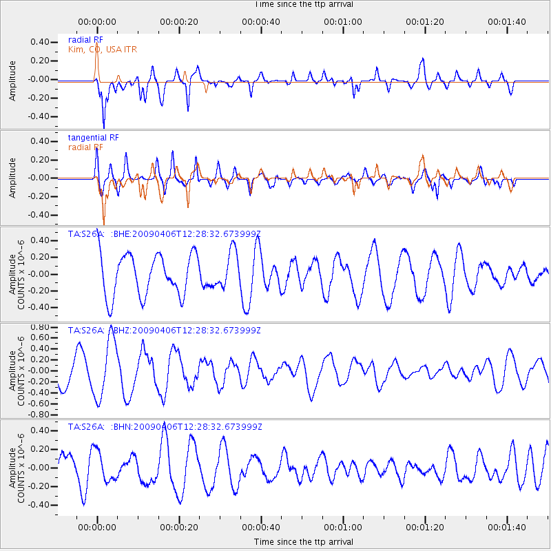
S26A Kim, CO, USA - Earthquake Result Viewer
*The percent match for this event was below the threshold and hence no stack was calculated.
| Earthquake location: |
Tonga Islands Region |
| Earthquake latitude/longitude: |
-22.4/-174.9 |
| Earthquake time(UTC): |
2009/04/06 (096) 12:16:08 GMT |
| Earthquake Depth: |
35 km |
| Earthquake Magnitude: |
5.5 MS, 5.4 MB |
| Earthquake Catalog/Contributor: |
WHDF/NEIC |
|
| Network: |
TA USArray Transportable Network (new EarthScope stations) |
| Station: |
S26A Kim, CO, USA |
| Lat/Lon: |
37.62 N/103.47 W |
| Elevation: |
1394 m |
|
| Distance: |
89.8 deg |
| Az: |
48.839 deg |
| Baz: |
241.349 deg |
| Ray Param: |
$rayparam |
*The percent match for this event was below the threshold and hence was not used in the summary stack. |
|
| Radial Match: |
71.790985 % |
| Radial Bump: |
400 |
| Transverse Match: |
77.48667 % |
| Transverse Bump: |
400 |
| SOD ConfigId: |
2658 |
| Insert Time: |
2010-03-06 20:04:24.209 +0000 |
| GWidth: |
2.5 |
| Max Bumps: |
400 |
| Tol: |
0.001 |
|
Signal To Noise
| Channel | StoN | STA | LTA |
| TA:S26A: :BHZ:20090406T12:28:32.673999Z | 1.5979171 | 5.519467E-7 | 3.4541637E-7 |
| TA:S26A: :BHN:20090406T12:28:32.673999Z | 1.1831567 | 1.6233595E-7 | 1.3720579E-7 |
| TA:S26A: :BHE:20090406T12:28:32.673999Z | 0.9066239 | 2.2543341E-7 | 2.4865153E-7 |
| Arrivals |
| Ps | |
| PpPs | |
| PsPs/PpSs | |


