You are here: Home > Network List > TA - USArray Transportable Network (new EarthScope stations) Stations List
> Station M26A McRoberts Ranch, Bridgeport, NE, USA > Earthquake Result Viewer
M26A McRoberts Ranch, Bridgeport, NE, USA - Earthquake Result Viewer
| Earthquake location: |
Norwegian Sea |
| Earthquake latitude/longitude: |
72.2/0.9 |
| Earthquake time(UTC): |
2009/08/20 (232) 06:35:04 GMT |
| Earthquake Depth: |
6.0 km |
| Earthquake Magnitude: |
5.9 MB, 5.7 MS, 6.0 MW, 6.0 MW |
| Earthquake Catalog/Contributor: |
WHDF/NEIC |
|
| Network: |
TA USArray Transportable Network (new EarthScope stations) |
| Station: |
M26A McRoberts Ranch, Bridgeport, NE, USA |
| Lat/Lon: |
41.47 N/103.14 W |
| Elevation: |
1348 m |
|
| Distance: |
55.1 deg |
| Az: |
297.344 deg |
| Baz: |
21.316 deg |
| Ray Param: |
0.06499417 |
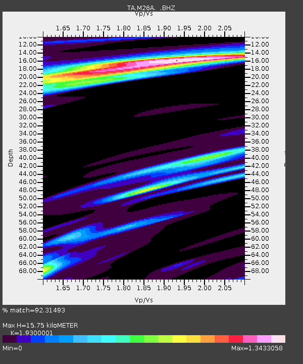
| Estimated Moho Depth: |
15.75 km |
| Estimated Crust Vp/Vs: |
1.93 |
| Assumed Crust Vp: |
6.483 km/s |
| Estimated Crust Vs: |
3.359 km/s |
| Estimated Crust Poisson's Ratio: |
0.32 |
|
| Radial Match: |
92.31493 % |
| Radial Bump: |
359 |
| Transverse Match: |
68.97997 % |
| Transverse Bump: |
400 |
| SOD ConfigId: |
2622 |
| Insert Time: |
2010-03-06 20:04:41.541 +0000 |
| GWidth: |
2.5 |
| Max Bumps: |
400 |
| Tol: |
0.001 |
|
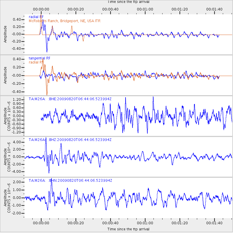
Signal To Noise
| Channel | StoN | STA | LTA |
| TA:M26A: :BHZ:20090820T06:44:06.523994Z | 14.866517 | 1.9830493E-6 | 1.333903E-7 |
| TA:M26A: :BHN:20090820T06:44:06.523994Z | 2.860425 | 5.8979987E-7 | 2.0619308E-7 |
| TA:M26A: :BHE:20090820T06:44:06.523994Z | 1.2020247 | 2.7146874E-7 | 2.258429E-7 |
| Arrivals |
| Ps | 2.4 SECOND |
| PpPs | 6.8 SECOND |
| PsPs/PpSs | 9.2 SECOND |


