You are here: Home > Network List > TA - USArray Transportable Network (new EarthScope stations) Stations List
> Station M26A McRoberts Ranch, Bridgeport, NE, USA > Earthquake Result Viewer
M26A McRoberts Ranch, Bridgeport, NE, USA - Earthquake Result Viewer
| Earthquake location: |
Hokkaido, Japan Region |
| Earthquake latitude/longitude: |
41.8/143.4 |
| Earthquake time(UTC): |
2009/06/05 (156) 03:30:33 GMT |
| Earthquake Depth: |
29 km |
| Earthquake Magnitude: |
6.0 MB, 6.3 MS, 6.4 MW, 6.4 MW |
| Earthquake Catalog/Contributor: |
WHDF/NEIC |
|
| Network: |
TA USArray Transportable Network (new EarthScope stations) |
| Station: |
M26A McRoberts Ranch, Bridgeport, NE, USA |
| Lat/Lon: |
41.47 N/103.14 W |
| Elevation: |
1348 m |
|
| Distance: |
77.6 deg |
| Az: |
44.926 deg |
| Baz: |
315.387 deg |
| Ray Param: |
0.050187472 |
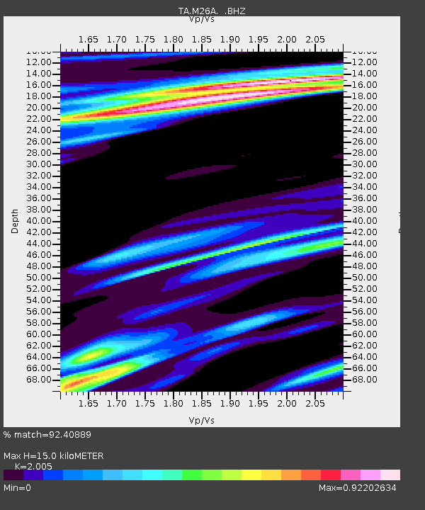
| Estimated Moho Depth: |
15.0 km |
| Estimated Crust Vp/Vs: |
2.01 |
| Assumed Crust Vp: |
6.483 km/s |
| Estimated Crust Vs: |
3.233 km/s |
| Estimated Crust Poisson's Ratio: |
0.33 |
|
| Radial Match: |
92.40889 % |
| Radial Bump: |
400 |
| Transverse Match: |
79.95396 % |
| Transverse Bump: |
400 |
| SOD ConfigId: |
2648 |
| Insert Time: |
2010-03-06 20:04:50.068 +0000 |
| GWidth: |
2.5 |
| Max Bumps: |
400 |
| Tol: |
0.001 |
|

Signal To Noise
| Channel | StoN | STA | LTA |
| TA:M26A: :BHZ:20090605T03:41:55.174014Z | 12.963296 | 1.4314315E-6 | 1.1042189E-7 |
| TA:M26A: :BHN:20090605T03:41:55.174014Z | 1.5897751 | 2.0808649E-7 | 1.3089051E-7 |
| TA:M26A: :BHE:20090605T03:41:55.174014Z | 2.5463033 | 4.1371513E-7 | 1.6247677E-7 |
| Arrivals |
| Ps | 2.4 SECOND |
| PpPs | 6.8 SECOND |
| PsPs/PpSs | 9.2 SECOND |


