You are here: Home > Network List > TA - USArray Transportable Network (new EarthScope stations) Stations List
> Station M26A McRoberts Ranch, Bridgeport, NE, USA > Earthquake Result Viewer
M26A McRoberts Ranch, Bridgeport, NE, USA - Earthquake Result Viewer
| Earthquake location: |
Panama |
| Earthquake latitude/longitude: |
9.6/-79.0 |
| Earthquake time(UTC): |
2009/07/04 (185) 06:49:35 GMT |
| Earthquake Depth: |
38 km |
| Earthquake Magnitude: |
6.0 MB, 5.5 MS, 6.0 MW, 6.0 MW |
| Earthquake Catalog/Contributor: |
WHDF/NEIC |
|
| Network: |
TA USArray Transportable Network (new EarthScope stations) |
| Station: |
M26A McRoberts Ranch, Bridgeport, NE, USA |
| Lat/Lon: |
41.47 N/103.14 W |
| Elevation: |
1348 m |
|
| Distance: |
38.2 deg |
| Az: |
330.184 deg |
| Baz: |
139.272 deg |
| Ray Param: |
0.07559061 |
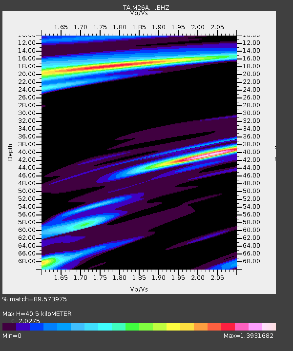
| Estimated Moho Depth: |
40.5 km |
| Estimated Crust Vp/Vs: |
2.03 |
| Assumed Crust Vp: |
6.483 km/s |
| Estimated Crust Vs: |
3.197 km/s |
| Estimated Crust Poisson's Ratio: |
0.34 |
|
| Radial Match: |
89.573975 % |
| Radial Bump: |
327 |
| Transverse Match: |
74.29236 % |
| Transverse Bump: |
400 |
| SOD ConfigId: |
2648 |
| Insert Time: |
2010-03-06 20:04:54.214 +0000 |
| GWidth: |
2.5 |
| Max Bumps: |
400 |
| Tol: |
0.001 |
|
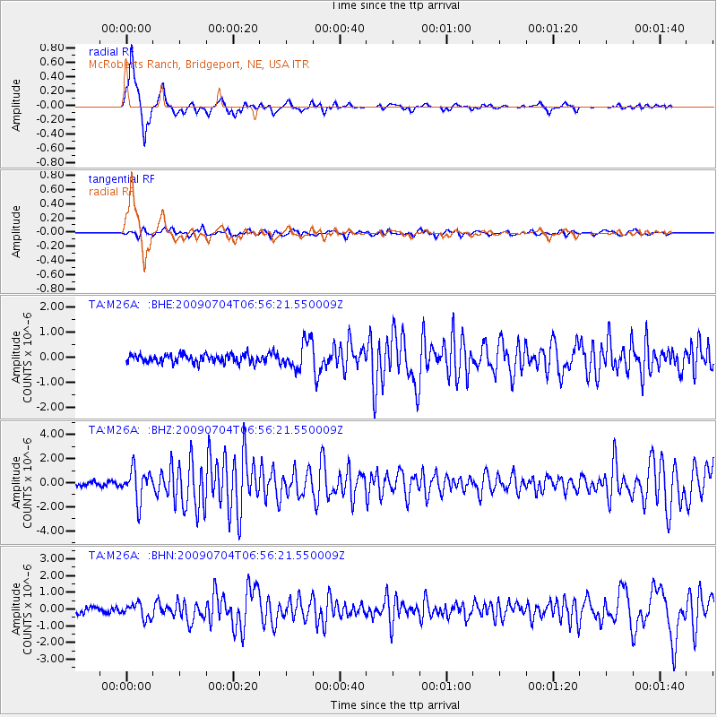
Signal To Noise
| Channel | StoN | STA | LTA |
| TA:M26A: :BHZ:20090704T06:56:21.550009Z | 8.37452 | 1.3027864E-6 | 1.5556549E-7 |
| TA:M26A: :BHN:20090704T06:56:21.550009Z | 2.5121279 | 4.4471312E-7 | 1.7702646E-7 |
| TA:M26A: :BHE:20090704T06:56:21.550009Z | 3.409419 | 5.530367E-7 | 1.622085E-7 |
| Arrivals |
| Ps | 6.8 SECOND |
| PpPs | 18 SECOND |
| PsPs/PpSs | 25 SECOND |


