You are here: Home > Network List > TA - USArray Transportable Network (new EarthScope stations) Stations List
> Station M26A McRoberts Ranch, Bridgeport, NE, USA > Earthquake Result Viewer
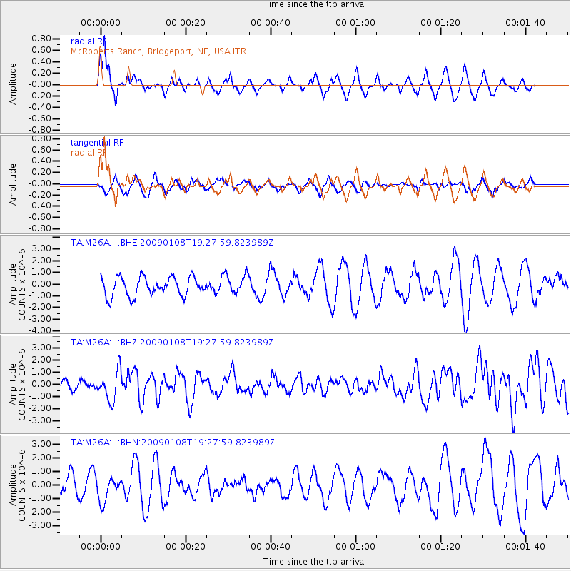
M26A McRoberts Ranch, Bridgeport, NE, USA - Earthquake Result Viewer
*The percent match for this event was below the threshold and hence no stack was calculated.
| Earthquake location: |
Costa Rica |
| Earthquake latitude/longitude: |
10.2/-84.2 |
| Earthquake time(UTC): |
2009/01/08 (008) 19:21:35 GMT |
| Earthquake Depth: |
14 km |
| Earthquake Magnitude: |
5.7 MB, 6.0 MS, 6.1 MW, 6.1 MW |
| Earthquake Catalog/Contributor: |
WHDF/NEIC |
|
| Network: |
TA USArray Transportable Network (new EarthScope stations) |
| Station: |
M26A McRoberts Ranch, Bridgeport, NE, USA |
| Lat/Lon: |
41.47 N/103.14 W |
| Elevation: |
1348 m |
|
| Distance: |
35.4 deg |
| Az: |
335.065 deg |
| Baz: |
146.477 deg |
| Ray Param: |
$rayparam |
*The percent match for this event was below the threshold and hence was not used in the summary stack. |
|
| Radial Match: |
52.654747 % |
| Radial Bump: |
394 |
| Transverse Match: |
43.985123 % |
| Transverse Bump: |
383 |
| SOD ConfigId: |
2834 |
| Insert Time: |
2010-03-06 20:05:03.579 +0000 |
| GWidth: |
2.5 |
| Max Bumps: |
400 |
| Tol: |
0.001 |
|
Signal To Noise
| Channel | StoN | STA | LTA |
| TA:M26A: :BHZ:20090108T19:27:59.823989Z | 4.2354274 | 1.2402515E-6 | 2.92828E-7 |
| TA:M26A: :BHN:20090108T19:27:59.823989Z | 1.1567072 | 8.5894476E-7 | 7.425775E-7 |
| TA:M26A: :BHE:20090108T19:27:59.823989Z | 1.0783156 | 8.6338406E-7 | 8.006784E-7 |
| Arrivals |
| Ps | |
| PpPs | |
| PsPs/PpSs | |


