You are here: Home > Network List > TA - USArray Transportable Network (new EarthScope stations) Stations List
> Station M26A McRoberts Ranch, Bridgeport, NE, USA > Earthquake Result Viewer
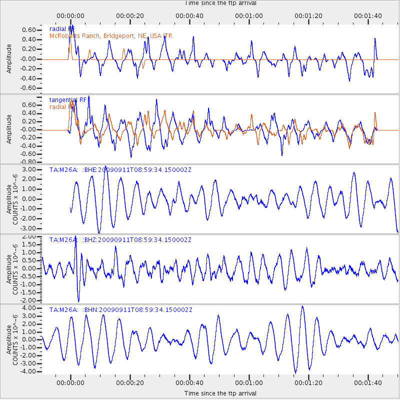
M26A McRoberts Ranch, Bridgeport, NE, USA - Earthquake Result Viewer
*The percent match for this event was below the threshold and hence no stack was calculated.
| Earthquake location: |
Kuril Islands |
| Earthquake latitude/longitude: |
48.3/154.2 |
| Earthquake time(UTC): |
2009/09/11 (254) 08:49:11 GMT |
| Earthquake Depth: |
35 km |
| Earthquake Magnitude: |
5.8 MB, 5.0 MS, 5.6 MW, 5.6 MW |
| Earthquake Catalog/Contributor: |
WHDF/NEIC |
|
| Network: |
TA USArray Transportable Network (new EarthScope stations) |
| Station: |
M26A McRoberts Ranch, Bridgeport, NE, USA |
| Lat/Lon: |
41.47 N/103.14 W |
| Elevation: |
1348 m |
|
| Distance: |
67.6 deg |
| Az: |
52.496 deg |
| Baz: |
315.178 deg |
| Ray Param: |
$rayparam |
*The percent match for this event was below the threshold and hence was not used in the summary stack. |
|
| Radial Match: |
39.65339 % |
| Radial Bump: |
339 |
| Transverse Match: |
48.031754 % |
| Transverse Bump: |
314 |
| SOD ConfigId: |
2622 |
| Insert Time: |
2010-03-06 20:05:17.000 +0000 |
| GWidth: |
2.5 |
| Max Bumps: |
400 |
| Tol: |
0.001 |
|
Signal To Noise
| Channel | StoN | STA | LTA |
| TA:M26A: :BHZ:20090911T08:59:34.150002Z | 1.7190064 | 9.501754E-7 | 5.527469E-7 |
| TA:M26A: :BHN:20090911T08:59:34.150002Z | 2.2492354 | 1.975741E-6 | 8.784056E-7 |
| TA:M26A: :BHE:20090911T08:59:34.150002Z | 0.42201155 | 7.2792045E-7 | 1.7248828E-6 |
| Arrivals |
| Ps | |
| PpPs | |
| PsPs/PpSs | |


