You are here: Home > Network List > TA - USArray Transportable Network (new EarthScope stations) Stations List
> Station M26A McRoberts Ranch, Bridgeport, NE, USA > Earthquake Result Viewer
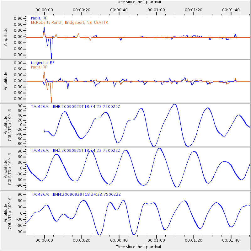
M26A McRoberts Ranch, Bridgeport, NE, USA - Earthquake Result Viewer
*The percent match for this event was below the threshold and hence no stack was calculated.
| Earthquake location: |
Tonga Islands |
| Earthquake latitude/longitude: |
-16.1/-173.3 |
| Earthquake time(UTC): |
2009/09/29 (272) 18:22:13 GMT |
| Earthquake Depth: |
10 km |
| Earthquake Magnitude: |
5.7 MB |
| Earthquake Catalog/Contributor: |
WHDF/NEIC |
|
| Network: |
TA USArray Transportable Network (new EarthScope stations) |
| Station: |
M26A McRoberts Ranch, Bridgeport, NE, USA |
| Lat/Lon: |
41.47 N/103.14 W |
| Elevation: |
1348 m |
|
| Distance: |
86.4 deg |
| Az: |
45.088 deg |
| Baz: |
244.919 deg |
| Ray Param: |
$rayparam |
*The percent match for this event was below the threshold and hence was not used in the summary stack. |
|
| Radial Match: |
91.67219 % |
| Radial Bump: |
272 |
| Transverse Match: |
61.571384 % |
| Transverse Bump: |
400 |
| SOD ConfigId: |
2622 |
| Insert Time: |
2010-03-06 20:05:23.405 +0000 |
| GWidth: |
2.5 |
| Max Bumps: |
400 |
| Tol: |
0.001 |
|
Signal To Noise
| Channel | StoN | STA | LTA |
| TA:M26A: :BHZ:20090929T18:34:23.750022Z | 1.0836537 | 4.1757143E-5 | 3.853366E-5 |
| TA:M26A: :BHN:20090929T18:34:23.750022Z | 1.50196 | 3.6306403E-5 | 2.4172683E-5 |
| TA:M26A: :BHE:20090929T18:34:23.750022Z | 1.6428752 | 5.7211397E-5 | 3.4823945E-5 |
| Arrivals |
| Ps | |
| PpPs | |
| PsPs/PpSs | |


