You are here: Home > Network List > TA - USArray Transportable Network (new EarthScope stations) Stations List
> Station M26A McRoberts Ranch, Bridgeport, NE, USA > Earthquake Result Viewer
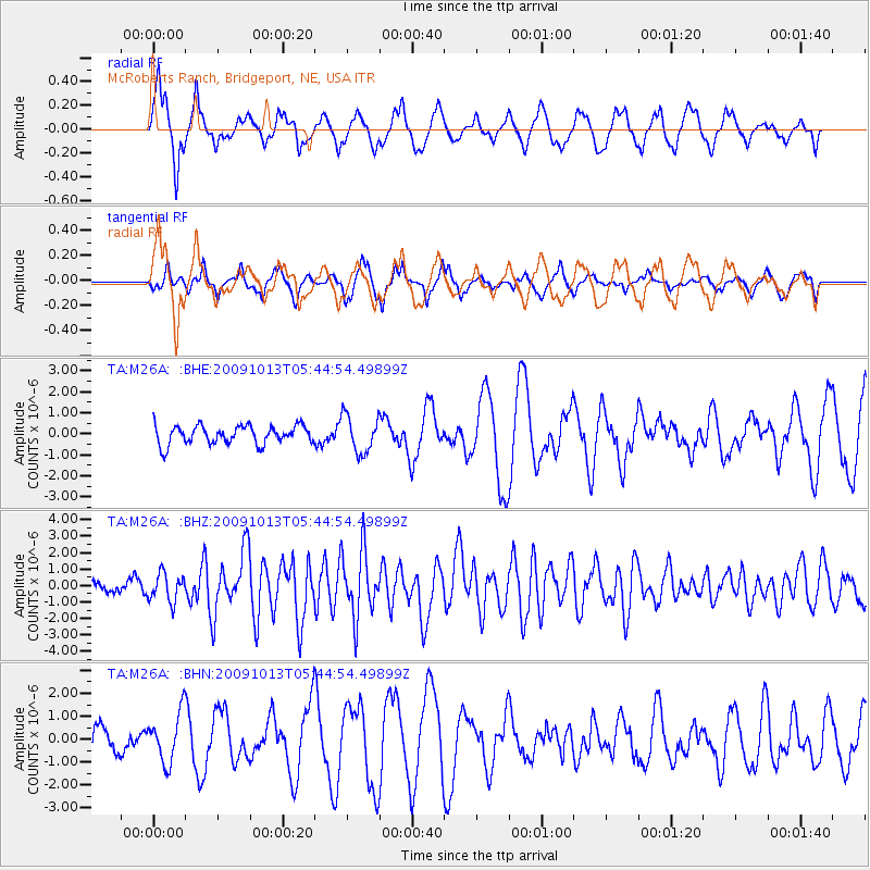
M26A McRoberts Ranch, Bridgeport, NE, USA - Earthquake Result Viewer
*The percent match for this event was below the threshold and hence no stack was calculated.
| Earthquake location: |
Fox Islands, Aleutian Islands |
| Earthquake latitude/longitude: |
52.8/-167.0 |
| Earthquake time(UTC): |
2009/10/13 (286) 05:37:23 GMT |
| Earthquake Depth: |
24 km |
| Earthquake Magnitude: |
6.0 MB, 6.1 MS, 6.5 MW, 6.5 MW |
| Earthquake Catalog/Contributor: |
WHDF/NEIC |
|
| Network: |
TA USArray Transportable Network (new EarthScope stations) |
| Station: |
M26A McRoberts Ranch, Bridgeport, NE, USA |
| Lat/Lon: |
41.47 N/103.14 W |
| Elevation: |
1348 m |
|
| Distance: |
43.5 deg |
| Az: |
78.441 deg |
| Baz: |
307.595 deg |
| Ray Param: |
$rayparam |
*The percent match for this event was below the threshold and hence was not used in the summary stack. |
|
| Radial Match: |
66.70635 % |
| Radial Bump: |
400 |
| Transverse Match: |
60.715034 % |
| Transverse Bump: |
327 |
| SOD ConfigId: |
2622 |
| Insert Time: |
2010-03-06 20:05:27.933 +0000 |
| GWidth: |
2.5 |
| Max Bumps: |
400 |
| Tol: |
0.001 |
|
Signal To Noise
| Channel | StoN | STA | LTA |
| TA:M26A: :BHZ:20091013T05:44:54.49899Z | 2.615641 | 8.4133404E-7 | 3.2165502E-7 |
| TA:M26A: :BHN:20091013T05:44:54.49899Z | 1.4404042 | 1.0679881E-6 | 7.414503E-7 |
| TA:M26A: :BHE:20091013T05:44:54.49899Z | 2.0212262 | 8.8626484E-7 | 4.3847882E-7 |
| Arrivals |
| Ps | |
| PpPs | |
| PsPs/PpSs | |


