You are here: Home > Network List > TA - USArray Transportable Network (new EarthScope stations) Stations List
> Station A21K Barrow, AK, USA > Earthquake Result Viewer
A21K Barrow, AK, USA - Earthquake Result Viewer
| Earthquake location: |
Mariana Islands |
| Earthquake latitude/longitude: |
19.1/145.8 |
| Earthquake time(UTC): |
2019/02/12 (043) 12:34:15 GMT |
| Earthquake Depth: |
130 km |
| Earthquake Magnitude: |
5.9 mww |
| Earthquake Catalog/Contributor: |
NEIC PDE/us |
|
| Network: |
TA USArray Transportable Network (new EarthScope stations) |
| Station: |
A21K Barrow, AK, USA |
| Lat/Lon: |
71.32 N/156.62 W |
| Elevation: |
577 m |
|
| Distance: |
61.9 deg |
| Az: |
17.96 deg |
| Baz: |
244.851 deg |
| Ray Param: |
0.0601863 |
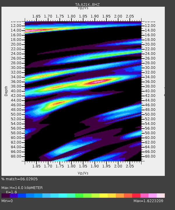
| Estimated Moho Depth: |
14.0 km |
| Estimated Crust Vp/Vs: |
1.60 |
| Assumed Crust Vp: |
6.048 km/s |
| Estimated Crust Vs: |
3.78 km/s |
| Estimated Crust Poisson's Ratio: |
0.18 |
|
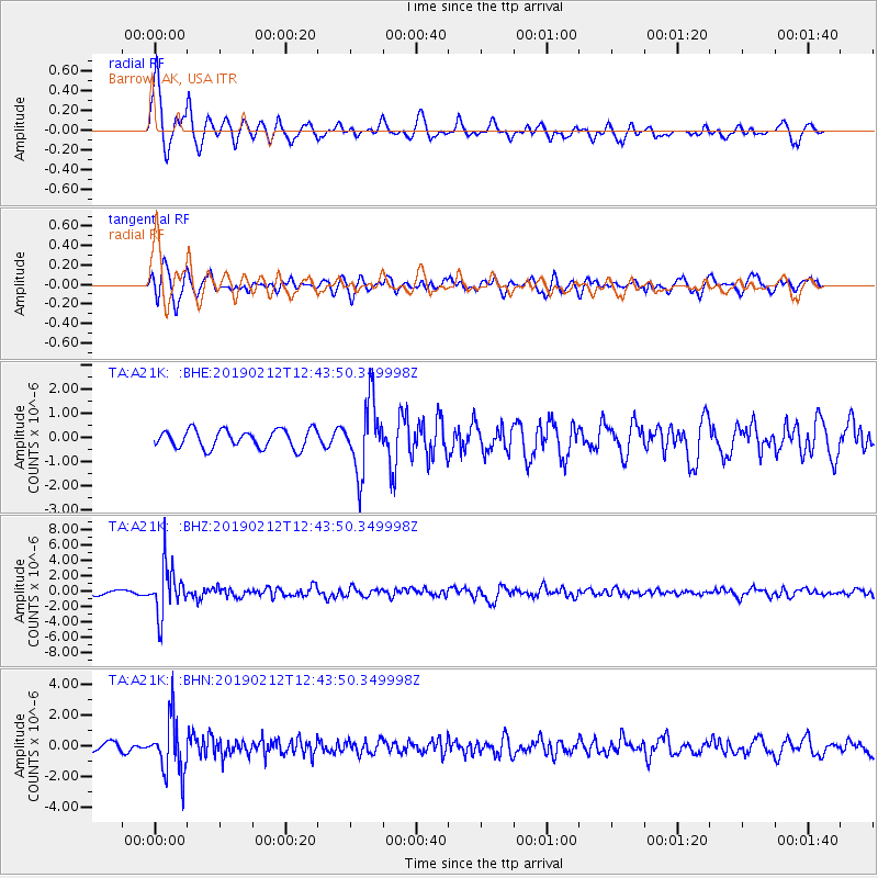
| Radial Match: |
86.02905 % |
| Radial Bump: |
306 |
| Transverse Match: |
74.02233 % |
| Transverse Bump: |
355 |
| SOD ConfigId: |
13570011 |
| Insert Time: |
2019-05-02 12:47:27.169 +0000 |
| GWidth: |
2.5 |
| Max Bumps: |
400 |
| Tol: |
0.001 |
|
Signal To Noise
| Channel | StoN | STA | LTA |
| TA:A21K: :BHZ:20190212T12:43:50.349998Z | 14.151914 | 3.1849877E-6 | 2.2505702E-7 |
| TA:A21K: :BHN:20190212T12:43:50.349998Z | 5.504538 | 1.789972E-6 | 3.2518113E-7 |
| TA:A21K: :BHE:20190212T12:43:50.349998Z | 3.8584845 | 1.442535E-6 | 3.738605E-7 |
| Arrivals |
| Ps | 1.5 SECOND |
| PpPs | 5.8 SECOND |
| PsPs/PpSs | 7.2 SECOND |


