You are here: Home > Network List > TA - USArray Transportable Network (new EarthScope stations) Stations List
> Station D23K Nanushuk River, AK USA > Earthquake Result Viewer
D23K Nanushuk River, AK USA - Earthquake Result Viewer
*The percent match for this event was below the threshold and hence no stack was calculated.
| Earthquake location: |
Mariana Islands |
| Earthquake latitude/longitude: |
19.1/145.8 |
| Earthquake time(UTC): |
2019/02/12 (043) 12:34:15 GMT |
| Earthquake Depth: |
130 km |
| Earthquake Magnitude: |
5.9 mww |
| Earthquake Catalog/Contributor: |
NEIC PDE/us |
|
| Network: |
TA USArray Transportable Network (new EarthScope stations) |
| Station: |
D23K Nanushuk River, AK USA |
| Lat/Lon: |
68.97 N/150.68 W |
| Elevation: |
406 m |
|
| Distance: |
62.9 deg |
| Az: |
21.284 deg |
| Baz: |
251.971 deg |
| Ray Param: |
$rayparam |
*The percent match for this event was below the threshold and hence was not used in the summary stack. |
|
| Radial Match: |
68.94465 % |
| Radial Bump: |
400 |
| Transverse Match: |
63.154804 % |
| Transverse Bump: |
400 |
| SOD ConfigId: |
13570011 |
| Insert Time: |
2019-05-02 12:47:38.094 +0000 |
| GWidth: |
2.5 |
| Max Bumps: |
400 |
| Tol: |
0.001 |
|
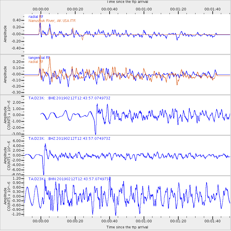
Signal To Noise
| Channel | StoN | STA | LTA |
| TA:D23K: :BHZ:20190212T12:43:57.074973Z | 5.2224364 | 2.9901648E-6 | 5.7256125E-7 |
| TA:D23K: :BHN:20190212T12:43:57.074973Z | 0.8146388 | 5.225208E-7 | 6.414141E-7 |
| TA:D23K: :BHE:20190212T12:43:57.074973Z | 3.4130297 | 1.2359087E-6 | 3.6211483E-7 |
| Arrivals |
| Ps | |
| PpPs | |
| PsPs/PpSs | |


