You are here: Home > Network List > TA - USArray Transportable Network (new EarthScope stations) Stations List
> Station F21K Alatna River, AK, USA > Earthquake Result Viewer
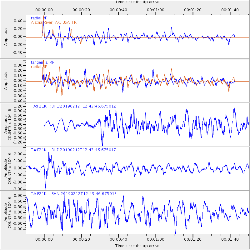
F21K Alatna River, AK, USA - Earthquake Result Viewer
*The percent match for this event was below the threshold and hence no stack was calculated.
| Earthquake location: |
Mariana Islands |
| Earthquake latitude/longitude: |
19.1/145.8 |
| Earthquake time(UTC): |
2019/02/12 (043) 12:34:15 GMT |
| Earthquake Depth: |
130 km |
| Earthquake Magnitude: |
5.9 mww |
| Earthquake Catalog/Contributor: |
NEIC PDE/us |
|
| Network: |
TA USArray Transportable Network (new EarthScope stations) |
| Station: |
F21K Alatna River, AK, USA |
| Lat/Lon: |
67.22 N/153.48 W |
| Elevation: |
597 m |
|
| Distance: |
61.4 deg |
| Az: |
22.77 deg |
| Baz: |
250.067 deg |
| Ray Param: |
$rayparam |
*The percent match for this event was below the threshold and hence was not used in the summary stack. |
|
| Radial Match: |
69.524765 % |
| Radial Bump: |
400 |
| Transverse Match: |
58.363853 % |
| Transverse Bump: |
400 |
| SOD ConfigId: |
13570011 |
| Insert Time: |
2019-05-02 12:47:51.626 +0000 |
| GWidth: |
2.5 |
| Max Bumps: |
400 |
| Tol: |
0.001 |
|
Signal To Noise
| Channel | StoN | STA | LTA |
| TA:F21K: :BHZ:20190212T12:43:46.67501Z | 3.4513855 | 1.2575341E-6 | 3.643563E-7 |
| TA:F21K: :BHN:20190212T12:43:46.67501Z | 0.75725687 | 2.7512993E-7 | 3.6332446E-7 |
| TA:F21K: :BHE:20190212T12:43:46.67501Z | 2.663998 | 5.563498E-7 | 2.0884018E-7 |
| Arrivals |
| Ps | |
| PpPs | |
| PsPs/PpSs | |


