You are here: Home > Network List > TA - USArray Transportable Network (new EarthScope stations) Stations List
> Station M26A McRoberts Ranch, Bridgeport, NE, USA > Earthquake Result Viewer
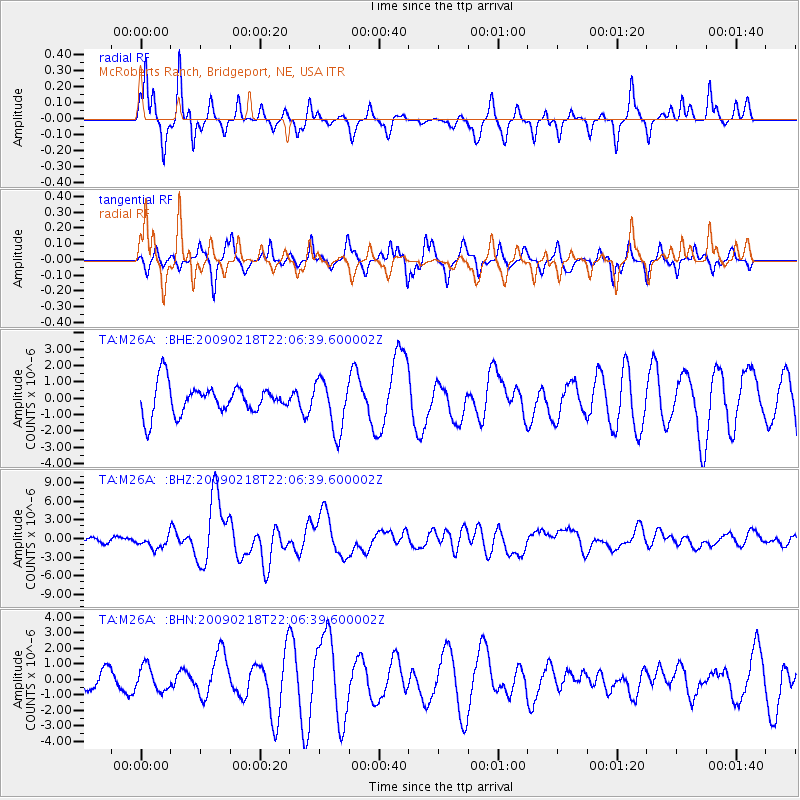
M26A McRoberts Ranch, Bridgeport, NE, USA - Earthquake Result Viewer
*The percent match for this event was below the threshold and hence no stack was calculated.
| Earthquake location: |
Kermadec Islands Region |
| Earthquake latitude/longitude: |
-27.4/-176.3 |
| Earthquake time(UTC): |
2009/02/18 (049) 21:53:45 GMT |
| Earthquake Depth: |
25 km |
| Earthquake Magnitude: |
6.8 MB, 7.2 MS, 6.9 MW, 6.9 MW |
| Earthquake Catalog/Contributor: |
WHDF/NEIC |
|
| Network: |
TA USArray Transportable Network (new EarthScope stations) |
| Station: |
M26A McRoberts Ranch, Bridgeport, NE, USA |
| Lat/Lon: |
41.47 N/103.14 W |
| Elevation: |
1348 m |
|
| Distance: |
96.3 deg |
| Az: |
46.364 deg |
| Baz: |
238.869 deg |
| Ray Param: |
$rayparam |
*The percent match for this event was below the threshold and hence was not used in the summary stack. |
|
| Radial Match: |
79.75215 % |
| Radial Bump: |
277 |
| Transverse Match: |
70.83729 % |
| Transverse Bump: |
293 |
| SOD ConfigId: |
2658 |
| Insert Time: |
2010-03-06 20:05:35.474 +0000 |
| GWidth: |
2.5 |
| Max Bumps: |
400 |
| Tol: |
0.001 |
|
Signal To Noise
| Channel | StoN | STA | LTA |
| TA:M26A: :BHZ:20090218T22:06:39.600002Z | 2.898649 | 1.0495617E-6 | 3.620865E-7 |
| TA:M26A: :BHN:20090218T22:06:39.600002Z | 1.403255 | 7.910845E-7 | 5.637497E-7 |
| TA:M26A: :BHE:20090218T22:06:39.600002Z | 1.7110373 | 1.5598204E-6 | 9.1162264E-7 |
| Arrivals |
| Ps | |
| PpPs | |
| PsPs/PpSs | |


