You are here: Home > Network List > TA - USArray Transportable Network (new EarthScope stations) Stations List
> Station I17K Unalakleet, AK, USA > Earthquake Result Viewer
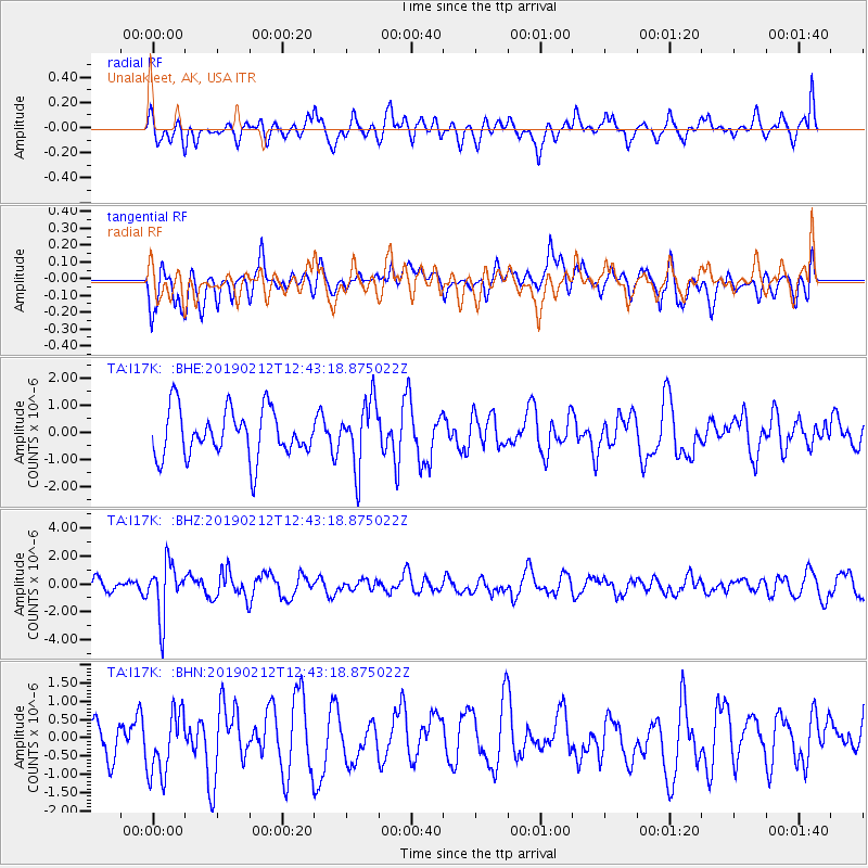
I17K Unalakleet, AK, USA - Earthquake Result Viewer
*The percent match for this event was below the threshold and hence no stack was calculated.
| Earthquake location: |
Mariana Islands |
| Earthquake latitude/longitude: |
19.1/145.8 |
| Earthquake time(UTC): |
2019/02/12 (043) 12:34:15 GMT |
| Earthquake Depth: |
130 km |
| Earthquake Magnitude: |
5.9 mww |
| Earthquake Catalog/Contributor: |
NEIC PDE/us |
|
| Network: |
TA USArray Transportable Network (new EarthScope stations) |
| Station: |
I17K Unalakleet, AK, USA |
| Lat/Lon: |
63.89 N/160.70 W |
| Elevation: |
105 m |
|
| Distance: |
57.3 deg |
| Az: |
25.015 deg |
| Baz: |
244.65 deg |
| Ray Param: |
$rayparam |
*The percent match for this event was below the threshold and hence was not used in the summary stack. |
|
| Radial Match: |
54.35449 % |
| Radial Bump: |
400 |
| Transverse Match: |
46.278217 % |
| Transverse Bump: |
400 |
| SOD ConfigId: |
13570011 |
| Insert Time: |
2019-05-02 12:48:15.971 +0000 |
| GWidth: |
2.5 |
| Max Bumps: |
400 |
| Tol: |
0.001 |
|
Signal To Noise
| Channel | StoN | STA | LTA |
| TA:I17K: :BHZ:20190212T12:43:18.875022Z | 4.519607 | 1.952447E-6 | 4.319949E-7 |
| TA:I17K: :BHN:20190212T12:43:18.875022Z | 1.3549907 | 8.942409E-7 | 6.5996085E-7 |
| TA:I17K: :BHE:20190212T12:43:18.875022Z | 1.3741238 | 1.2071021E-6 | 8.7845217E-7 |
| Arrivals |
| Ps | |
| PpPs | |
| PsPs/PpSs | |


