You are here: Home > Network List > TA - USArray Transportable Network (new EarthScope stations) Stations List
> Station I23K Minto, Yukon-Koyukuk, AK, USA > Earthquake Result Viewer
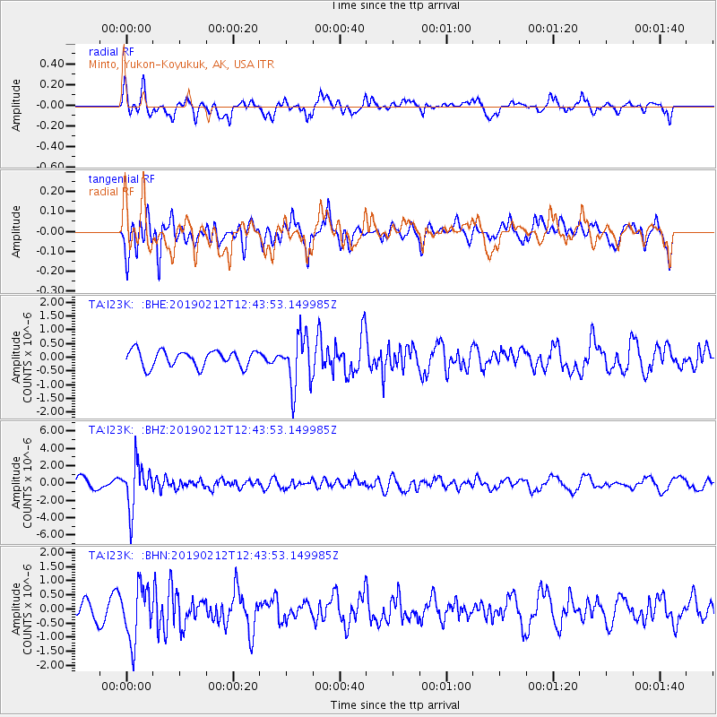
I23K Minto, Yukon-Koyukuk, AK, USA - Earthquake Result Viewer
*The percent match for this event was below the threshold and hence no stack was calculated.
| Earthquake location: |
Mariana Islands |
| Earthquake latitude/longitude: |
19.1/145.8 |
| Earthquake time(UTC): |
2019/02/12 (043) 12:34:15 GMT |
| Earthquake Depth: |
130 km |
| Earthquake Magnitude: |
5.9 mww |
| Earthquake Catalog/Contributor: |
NEIC PDE/us |
|
| Network: |
TA USArray Transportable Network (new EarthScope stations) |
| Station: |
I23K Minto, Yukon-Koyukuk, AK, USA |
| Lat/Lon: |
65.15 N/149.36 W |
| Elevation: |
149 m |
|
| Distance: |
62.3 deg |
| Az: |
25.591 deg |
| Baz: |
255.166 deg |
| Ray Param: |
$rayparam |
*The percent match for this event was below the threshold and hence was not used in the summary stack. |
|
| Radial Match: |
68.81933 % |
| Radial Bump: |
364 |
| Transverse Match: |
50.5621 % |
| Transverse Bump: |
382 |
| SOD ConfigId: |
13570011 |
| Insert Time: |
2019-05-02 12:48:17.165 +0000 |
| GWidth: |
2.5 |
| Max Bumps: |
400 |
| Tol: |
0.001 |
|
Signal To Noise
| Channel | StoN | STA | LTA |
| TA:I23K: :BHZ:20190212T12:43:53.149985Z | 6.226248 | 2.5301442E-6 | 4.063674E-7 |
| TA:I23K: :BHN:20190212T12:43:53.149985Z | 2.2975914 | 9.550905E-7 | 4.1569206E-7 |
| TA:I23K: :BHE:20190212T12:43:53.149985Z | 3.25344 | 9.575608E-7 | 2.9432258E-7 |
| Arrivals |
| Ps | |
| PpPs | |
| PsPs/PpSs | |


