You are here: Home > Network List > IU - Global Seismograph Network (GSN - IRIS/USGS) Stations List
> Station PMG Port Moresby, New Guinea > Earthquake Result Viewer
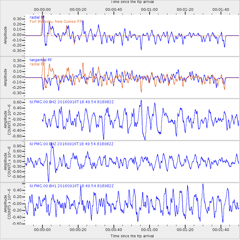
PMG Port Moresby, New Guinea - Earthquake Result Viewer
*The percent match for this event was below the threshold and hence no stack was calculated.
| Earthquake location: |
Southwest Indian Ridge |
| Earthquake latitude/longitude: |
-29.1/60.9 |
| Earthquake time(UTC): |
2016/09/16 (260) 18:38:05 GMT |
| Earthquake Depth: |
10 km |
| Earthquake Magnitude: |
5.5 MB, 5.4 MWB, 5.5 MWC |
| Earthquake Catalog/Contributor: |
NEIC PDE/NEIC COMCAT |
|
| Network: |
IU Global Seismograph Network (GSN - IRIS/USGS) |
| Station: |
PMG Port Moresby, New Guinea |
| Lat/Lon: |
9.40 S/147.16 E |
| Elevation: |
90 m |
|
| Distance: |
82.2 deg |
| Az: |
96.407 deg |
| Baz: |
241.769 deg |
| Ray Param: |
$rayparam |
*The percent match for this event was below the threshold and hence was not used in the summary stack. |
|
| Radial Match: |
50.431866 % |
| Radial Bump: |
400 |
| Transverse Match: |
51.15935 % |
| Transverse Bump: |
400 |
| SOD ConfigId: |
1634031 |
| Insert Time: |
2016-09-30 18:41:56.986 +0000 |
| GWidth: |
2.5 |
| Max Bumps: |
400 |
| Tol: |
0.001 |
|
Signal To Noise
| Channel | StoN | STA | LTA |
| IU:PMG:00:BHZ:20160916T18:49:54.818982Z | 3.7699668 | 4.2521296E-7 | 1.1278958E-7 |
| IU:PMG:00:BH1:20160916T18:49:54.818982Z | 0.78656167 | 1.719519E-7 | 2.1861212E-7 |
| IU:PMG:00:BH2:20160916T18:49:54.818982Z | 1.3309984 | 2.673449E-7 | 2.0086041E-7 |
| Arrivals |
| Ps | |
| PpPs | |
| PsPs/PpSs | |


