You are here: Home > Network List > TA - USArray Transportable Network (new EarthScope stations) Stations List
> Station O17K Koliganek, Bristol Bay, AK, USA > Earthquake Result Viewer
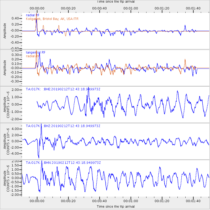
O17K Koliganek, Bristol Bay, AK, USA - Earthquake Result Viewer
*The percent match for this event was below the threshold and hence no stack was calculated.
| Earthquake location: |
Mariana Islands |
| Earthquake latitude/longitude: |
19.1/145.8 |
| Earthquake time(UTC): |
2019/02/12 (043) 12:34:15 GMT |
| Earthquake Depth: |
130 km |
| Earthquake Magnitude: |
5.9 mww |
| Earthquake Catalog/Contributor: |
NEIC PDE/us |
|
| Network: |
TA USArray Transportable Network (new EarthScope stations) |
| Station: |
O17K Koliganek, Bristol Bay, AK, USA |
| Lat/Lon: |
59.77 N/157.09 W |
| Elevation: |
156 m |
|
| Distance: |
57.3 deg |
| Az: |
30.322 deg |
| Baz: |
250.689 deg |
| Ray Param: |
$rayparam |
*The percent match for this event was below the threshold and hence was not used in the summary stack. |
|
| Radial Match: |
58.71032 % |
| Radial Bump: |
396 |
| Transverse Match: |
66.60205 % |
| Transverse Bump: |
348 |
| SOD ConfigId: |
13570011 |
| Insert Time: |
2019-05-02 12:49:00.540 +0000 |
| GWidth: |
2.5 |
| Max Bumps: |
400 |
| Tol: |
0.001 |
|
Signal To Noise
| Channel | StoN | STA | LTA |
| TA:O17K: :BHZ:20190212T12:43:18.949973Z | 4.404464 | 2.4666258E-6 | 5.6002864E-7 |
| TA:O17K: :BHN:20190212T12:43:18.949973Z | 2.0399594 | 9.860363E-7 | 4.8336074E-7 |
| TA:O17K: :BHE:20190212T12:43:18.949973Z | 1.7759047 | 1.0559111E-6 | 5.945765E-7 |
| Arrivals |
| Ps | |
| PpPs | |
| PsPs/PpSs | |


