You are here: Home > Network List > TS - TERRAscope (Southern California Seismic Network) Stations List
> Station CWC Cottonwood Creek Canyon, California, USA > Earthquake Result Viewer
CWC Cottonwood Creek Canyon, California, USA - Earthquake Result Viewer
| Earthquake location: |
Vanuatu Islands |
| Earthquake latitude/longitude: |
-19.5/169.2 |
| Earthquake time(UTC): |
1995/06/29 (180) 12:24:03 GMT |
| Earthquake Depth: |
144 km |
| Earthquake Magnitude: |
6.2 MB, 6.7 UNKNOWN, 6.6 MW |
| Earthquake Catalog/Contributor: |
WHDF/NEIC |
|
| Network: |
TS TERRAscope (Southern California Seismic Network) |
| Station: |
CWC Cottonwood Creek Canyon, California, USA |
| Lat/Lon: |
36.44 N/118.08 W |
| Elevation: |
1553 m |
|
| Distance: |
88.2 deg |
| Az: |
50.37 deg |
| Baz: |
244.314 deg |
| Ray Param: |
0.042411253 |
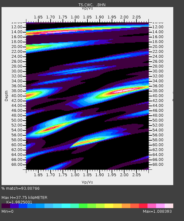
| Estimated Moho Depth: |
37.75 km |
| Estimated Crust Vp/Vs: |
1.99 |
| Assumed Crust Vp: |
6.291 km/s |
| Estimated Crust Vs: |
3.157 km/s |
| Estimated Crust Poisson's Ratio: |
0.33 |
|
| Radial Match: |
93.88766 % |
| Radial Bump: |
400 |
| Transverse Match: |
89.32049 % |
| Transverse Bump: |
400 |
| SOD ConfigId: |
6273 |
| Insert Time: |
2010-02-26 14:05:30.612 +0000 |
| GWidth: |
2.5 |
| Max Bumps: |
400 |
| Tol: |
0.001 |
|

Signal To Noise
| Channel | StoN | STA | LTA |
| TS:CWC: :BHN:19950629T12:36:07.663Z | 3.5922735 | 4.0439443E-7 | 1.12573396E-7 |
| TS:CWC: :BHE:19950629T12:36:07.663Z | 5.440637 | 6.60217E-7 | 1.213492E-7 |
| TS:CWC: :BHZ:19950629T12:36:07.663Z | 46.289936 | 3.0428553E-6 | 6.57347E-8 |
| Arrivals |
| Ps | 6.1 SECOND |
| PpPs | 18 SECOND |
| PsPs/PpSs | 24 SECOND |


