You are here: Home > Network List > TA - USArray Transportable Network (new EarthScope stations) Stations List
> Station M26A McRoberts Ranch, Bridgeport, NE, USA > Earthquake Result Viewer
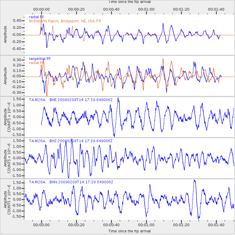
M26A McRoberts Ranch, Bridgeport, NE, USA - Earthquake Result Viewer
*The percent match for this event was below the threshold and hence no stack was calculated.
| Earthquake location: |
Near Coast Of Northern Peru |
| Earthquake latitude/longitude: |
-6.6/-81.2 |
| Earthquake time(UTC): |
2009/02/09 (040) 14:09:02 GMT |
| Earthquake Depth: |
15 km |
| Earthquake Magnitude: |
5.5 MB, 5.5 MS, 6.0 MW, 5.9 MW |
| Earthquake Catalog/Contributor: |
WHDF/NEIC |
|
| Network: |
TA USArray Transportable Network (new EarthScope stations) |
| Station: |
M26A McRoberts Ranch, Bridgeport, NE, USA |
| Lat/Lon: |
41.47 N/103.14 W |
| Elevation: |
1348 m |
|
| Distance: |
51.9 deg |
| Az: |
339.036 deg |
| Baz: |
151.772 deg |
| Ray Param: |
$rayparam |
*The percent match for this event was below the threshold and hence was not used in the summary stack. |
|
| Radial Match: |
62.378273 % |
| Radial Bump: |
400 |
| Transverse Match: |
46.789257 % |
| Transverse Bump: |
312 |
| SOD ConfigId: |
2658 |
| Insert Time: |
2010-03-06 20:06:01.325 +0000 |
| GWidth: |
2.5 |
| Max Bumps: |
400 |
| Tol: |
0.001 |
|
Signal To Noise
| Channel | StoN | STA | LTA |
| TA:M26A: :BHZ:20090209T14:17:39.649006Z | 3.0505626 | 6.8247175E-7 | 2.2371997E-7 |
| TA:M26A: :BHN:20090209T14:17:39.649006Z | 1.6434768 | 5.483056E-7 | 3.336254E-7 |
| TA:M26A: :BHE:20090209T14:17:39.649006Z | 1.0753232 | 4.1768809E-7 | 3.8843027E-7 |
| Arrivals |
| Ps | |
| PpPs | |
| PsPs/PpSs | |


