You are here: Home > Network List > TA - USArray Transportable Network (new EarthScope stations) Stations List
> Station R27A Eads, CO, USA > Earthquake Result Viewer
R27A Eads, CO, USA - Earthquake Result Viewer
| Earthquake location: |
Near S. Coast Of Honshu, Japan |
| Earthquake latitude/longitude: |
33.2/137.9 |
| Earthquake time(UTC): |
2009/08/09 (221) 10:55:55 GMT |
| Earthquake Depth: |
297 km |
| Earthquake Magnitude: |
6.5 MB, 7.1 MW, 7.1 MW |
| Earthquake Catalog/Contributor: |
WHDF/NEIC |
|
| Network: |
TA USArray Transportable Network (new EarthScope stations) |
| Station: |
R27A Eads, CO, USA |
| Lat/Lon: |
38.29 N/102.80 W |
| Elevation: |
1201 m |
|
| Distance: |
89.2 deg |
| Az: |
43.361 deg |
| Baz: |
312.963 deg |
| Ray Param: |
0.04168979 |
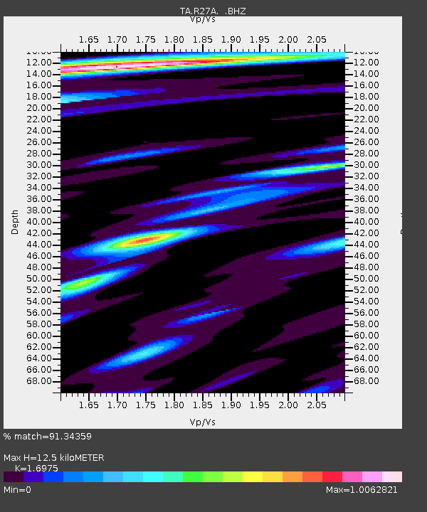
| Estimated Moho Depth: |
12.5 km |
| Estimated Crust Vp/Vs: |
1.70 |
| Assumed Crust Vp: |
6.242 km/s |
| Estimated Crust Vs: |
3.677 km/s |
| Estimated Crust Poisson's Ratio: |
0.23 |
|
| Radial Match: |
91.34359 % |
| Radial Bump: |
400 |
| Transverse Match: |
79.318565 % |
| Transverse Bump: |
400 |
| SOD ConfigId: |
2622 |
| Insert Time: |
2010-03-06 20:06:14.687 +0000 |
| GWidth: |
2.5 |
| Max Bumps: |
400 |
| Tol: |
0.001 |
|
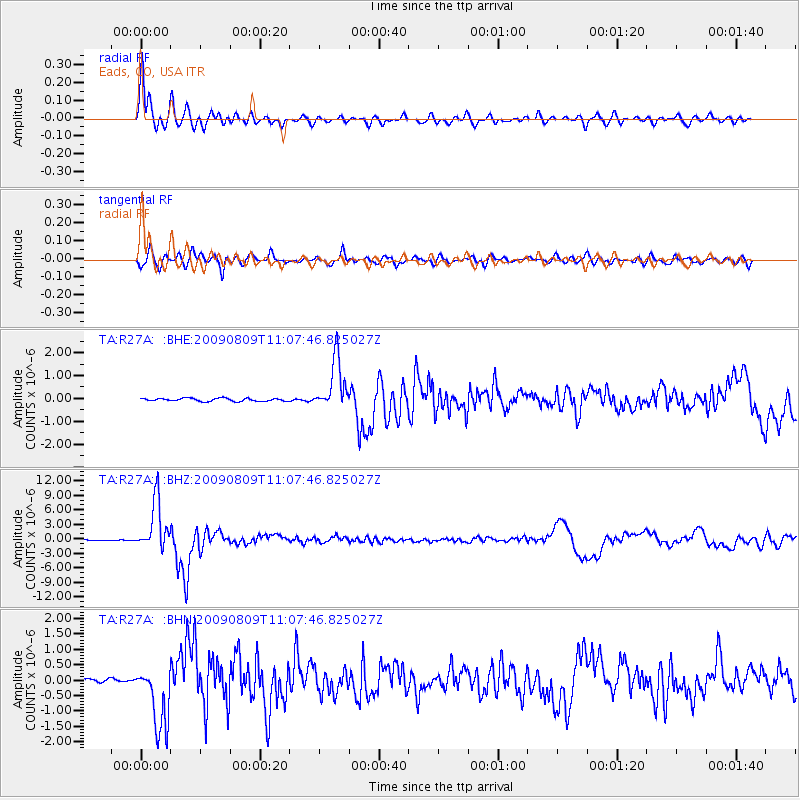
Signal To Noise
| Channel | StoN | STA | LTA |
| TA:R27A: :BHZ:20090809T11:07:46.825027Z | 66.1977 | 5.1052266E-6 | 7.71209E-8 |
| TA:R27A: :BHN:20090809T11:07:46.825027Z | 20.633595 | 1.0570161E-6 | 5.122792E-8 |
| TA:R27A: :BHE:20090809T11:07:46.825027Z | 17.110401 | 1.100076E-6 | 6.429282E-8 |
| Arrivals |
| Ps | 1.4 SECOND |
| PpPs | 5.3 SECOND |
| PsPs/PpSs | 6.7 SECOND |


