You are here: Home > Network List > TA - USArray Transportable Network (new EarthScope stations) Stations List
> Station R27A Eads, CO, USA > Earthquake Result Viewer
R27A Eads, CO, USA - Earthquake Result Viewer
| Earthquake location: |
Samoa Islands Region |
| Earthquake latitude/longitude: |
-15.2/-172.6 |
| Earthquake time(UTC): |
2009/08/30 (242) 14:51:32 GMT |
| Earthquake Depth: |
11 km |
| Earthquake Magnitude: |
6.4 MB, 6.3 MS, 6.6 MW, 6.6 MW |
| Earthquake Catalog/Contributor: |
WHDF/NEIC |
|
| Network: |
TA USArray Transportable Network (new EarthScope stations) |
| Station: |
R27A Eads, CO, USA |
| Lat/Lon: |
38.29 N/102.80 W |
| Elevation: |
1201 m |
|
| Distance: |
84.2 deg |
| Az: |
47.924 deg |
| Baz: |
245.58 deg |
| Ray Param: |
0.04567255 |
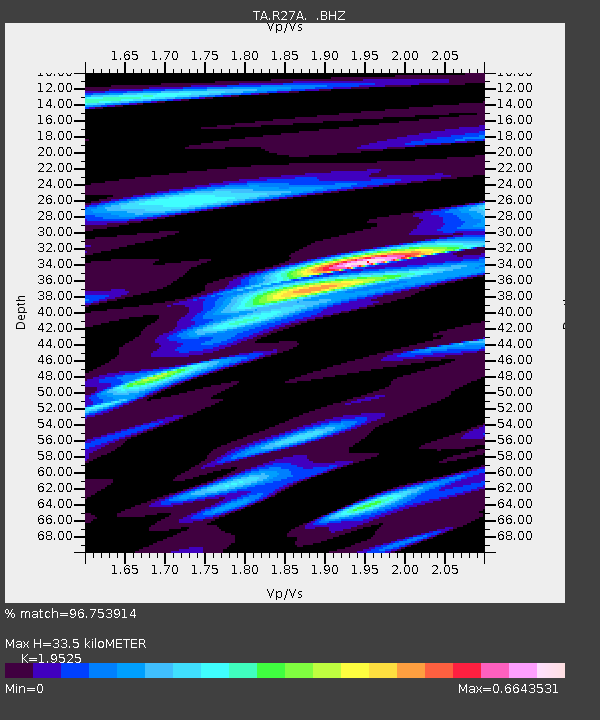
| Estimated Moho Depth: |
33.5 km |
| Estimated Crust Vp/Vs: |
1.95 |
| Assumed Crust Vp: |
6.242 km/s |
| Estimated Crust Vs: |
3.197 km/s |
| Estimated Crust Poisson's Ratio: |
0.32 |
|
| Radial Match: |
96.753914 % |
| Radial Bump: |
324 |
| Transverse Match: |
88.59465 % |
| Transverse Bump: |
400 |
| SOD ConfigId: |
2622 |
| Insert Time: |
2010-03-06 20:06:19.735 +0000 |
| GWidth: |
2.5 |
| Max Bumps: |
400 |
| Tol: |
0.001 |
|

Signal To Noise
| Channel | StoN | STA | LTA |
| TA:R27A: :BHZ:20090830T15:03:32.52501Z | 54.025127 | 3.1370803E-6 | 5.8067055E-8 |
| TA:R27A: :BHN:20090830T15:03:32.52501Z | 7.585327 | 9.340612E-7 | 1.2314052E-7 |
| TA:R27A: :BHE:20090830T15:03:32.52501Z | 11.404042 | 1.1910987E-6 | 1.04445306E-7 |
| Arrivals |
| Ps | 5.2 SECOND |
| PpPs | 16 SECOND |
| PsPs/PpSs | 21 SECOND |


