You are here: Home > Network List > TA - USArray Transportable Network (new EarthScope stations) Stations List
> Station R27A Eads, CO, USA > Earthquake Result Viewer
R27A Eads, CO, USA - Earthquake Result Viewer

| Earthquake location: |
Tonga Islands |
| Earthquake latitude/longitude: |
-15.4/-173.2 |
| Earthquake time(UTC): |
2009/09/29 (272) 18:40:09 GMT |
| Earthquake Depth: |
2.3 km |
| Earthquake Magnitude: |
5.5 MB |
| Earthquake Catalog/Contributor: |
WHDF/NEIC |
|
| Network: |
TA USArray Transportable Network (new EarthScope stations) |
| Station: |
R27A Eads, CO, USA |
| Lat/Lon: |
38.29 N/102.80 W |
| Elevation: |
1201 m |
|
| Distance: |
84.7 deg |
| Az: |
48.132 deg |
| Baz: |
245.913 deg |
| Ray Param: |
0.045283277 |
| Estimated Moho Depth: |
52.25 km |
| Estimated Crust Vp/Vs: |
1.85 |
| Assumed Crust Vp: |
6.242 km/s |
| Estimated Crust Vs: |
3.374 km/s |
| Estimated Crust Poisson's Ratio: |
0.29 |
|
| Radial Match: |
91.855385 % |
| Radial Bump: |
400 |
| Transverse Match: |
90.75719 % |
| Transverse Bump: |
375 |
| SOD ConfigId: |
2622 |
| Insert Time: |
2010-03-06 20:06:23.652 +0000 |
| GWidth: |
2.5 |
| Max Bumps: |
400 |
| Tol: |
0.001 |
|
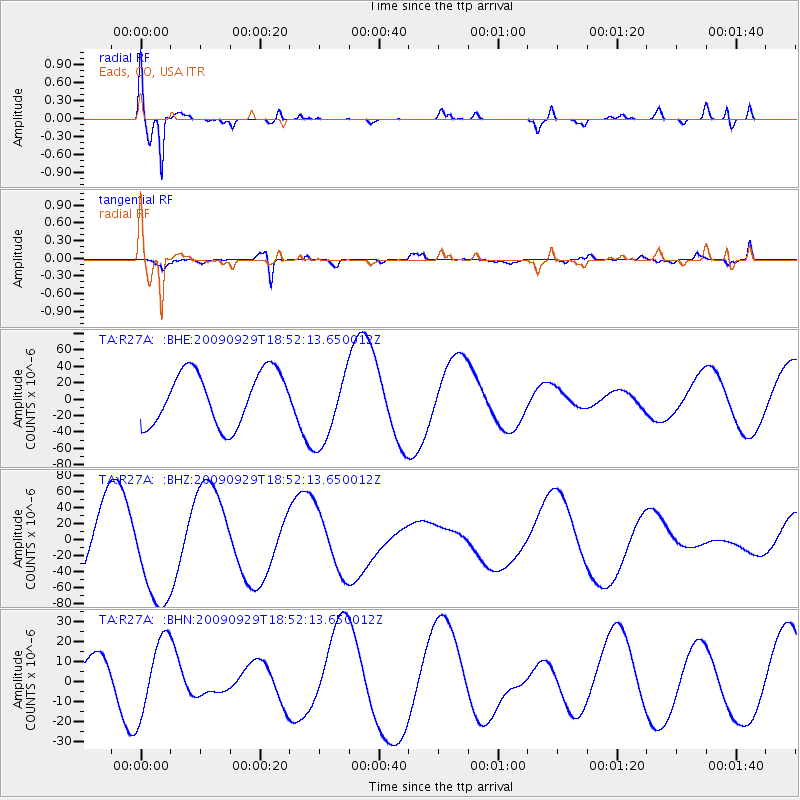
Signal To Noise
| Channel | StoN | STA | LTA |
| TA:R27A: :BHZ:20090929T18:52:13.650012Z | 1.5568918 | 6.1542225E-5 | 3.9528906E-5 |
| TA:R27A: :BHN:20090929T18:52:13.650012Z | 1.3613005 | 1.9148272E-5 | 1.4066161E-5 |
| TA:R27A: :BHE:20090929T18:52:13.650012Z | 1.4141651 | 4.583839E-5 | 3.2413747E-5 |
| Arrivals |
| Ps | 7.3 SECOND |
| PpPs | 23 SECOND |
| PsPs/PpSs | 31 SECOND |


