You are here: Home > Network List > TA - USArray Transportable Network (new EarthScope stations) Stations List
> Station R27A Eads, CO, USA > Earthquake Result Viewer
R27A Eads, CO, USA - Earthquake Result Viewer

| Earthquake location: |
Azores Islands Region |
| Earthquake latitude/longitude: |
36.2/-33.9 |
| Earthquake time(UTC): |
2009/11/04 (308) 18:41:44 GMT |
| Earthquake Depth: |
10 km |
| Earthquake Magnitude: |
5.7 MB, 5.6 MS, 5.9 MW, 5.8 MW |
| Earthquake Catalog/Contributor: |
WHDF/NEIC |
|
| Network: |
TA USArray Transportable Network (new EarthScope stations) |
| Station: |
R27A Eads, CO, USA |
| Lat/Lon: |
38.29 N/102.80 W |
| Elevation: |
1201 m |
|
| Distance: |
53.7 deg |
| Az: |
294.403 deg |
| Baz: |
69.479 deg |
| Ray Param: |
0.065897524 |
| Estimated Moho Depth: |
39.0 km |
| Estimated Crust Vp/Vs: |
1.86 |
| Assumed Crust Vp: |
6.242 km/s |
| Estimated Crust Vs: |
3.36 km/s |
| Estimated Crust Poisson's Ratio: |
0.30 |
|
| Radial Match: |
82.74296 % |
| Radial Bump: |
210 |
| Transverse Match: |
78.69087 % |
| Transverse Bump: |
340 |
| SOD ConfigId: |
2622 |
| Insert Time: |
2010-03-06 20:06:29.166 +0000 |
| GWidth: |
2.5 |
| Max Bumps: |
400 |
| Tol: |
0.001 |
|
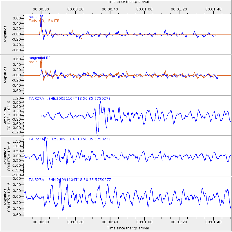
Signal To Noise
| Channel | StoN | STA | LTA |
| TA:R27A: :BHZ:20091104T18:50:35.575027Z | 8.347837 | 1.0776876E-6 | 1.2909783E-7 |
| TA:R27A: :BHN:20091104T18:50:35.575027Z | 1.1536143 | 1.2109257E-7 | 1.0496799E-7 |
| TA:R27A: :BHE:20091104T18:50:35.575027Z | 5.8086805 | 7.342707E-7 | 1.264092E-7 |
| Arrivals |
| Ps | 5.6 SECOND |
| PpPs | 17 SECOND |
| PsPs/PpSs | 23 SECOND |


