You are here: Home > Network List > TA - USArray Transportable Network (new EarthScope stations) Stations List
> Station R27A Eads, CO, USA > Earthquake Result Viewer
R27A Eads, CO, USA - Earthquake Result Viewer
| Earthquake location: |
Tonga Islands Region |
| Earthquake latitude/longitude: |
-17.3/-171.9 |
| Earthquake time(UTC): |
2008/12/24 (359) 09:11:34 GMT |
| Earthquake Depth: |
9.0 km |
| Earthquake Magnitude: |
5.9 MB, 5.6 MS, 6.0 MW, 6.0 MW |
| Earthquake Catalog/Contributor: |
WHDF/NEIC |
|
| Network: |
TA USArray Transportable Network (new EarthScope stations) |
| Station: |
R27A Eads, CO, USA |
| Lat/Lon: |
38.29 N/102.80 W |
| Elevation: |
1201 m |
|
| Distance: |
85.1 deg |
| Az: |
47.557 deg |
| Baz: |
243.622 deg |
| Ray Param: |
0.045025155 |
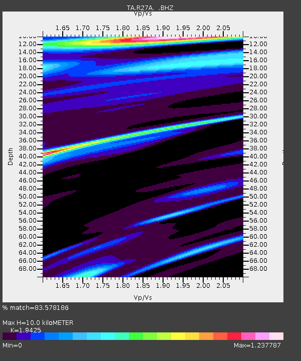
| Estimated Moho Depth: |
10.0 km |
| Estimated Crust Vp/Vs: |
1.94 |
| Assumed Crust Vp: |
6.242 km/s |
| Estimated Crust Vs: |
3.213 km/s |
| Estimated Crust Poisson's Ratio: |
0.32 |
|
| Radial Match: |
83.578186 % |
| Radial Bump: |
400 |
| Transverse Match: |
53.75124 % |
| Transverse Bump: |
271 |
| SOD ConfigId: |
2658 |
| Insert Time: |
2010-03-06 20:06:40.149 +0000 |
| GWidth: |
2.5 |
| Max Bumps: |
400 |
| Tol: |
0.001 |
|

Signal To Noise
| Channel | StoN | STA | LTA |
| TA:R27A: :BHZ:20081224T09:23:38.849021Z | 1.4713117 | 9.2276457E-7 | 6.2717135E-7 |
| TA:R27A: :BHN:20081224T09:23:38.849021Z | 2.2364023 | 6.51711E-7 | 2.9141046E-7 |
| TA:R27A: :BHE:20081224T09:23:38.849021Z | 0.90622205 | 5.863701E-7 | 6.470491E-7 |
| Arrivals |
| Ps | 1.5 SECOND |
| PpPs | 4.6 SECOND |
| PsPs/PpSs | 6.2 SECOND |


