You are here: Home > Network List > TA - USArray Transportable Network (new EarthScope stations) Stations List
> Station R27A Eads, CO, USA > Earthquake Result Viewer
R27A Eads, CO, USA - Earthquake Result Viewer

| Earthquake location: |
Baffin Bay |
| Earthquake latitude/longitude: |
75.4/-72.5 |
| Earthquake time(UTC): |
2009/07/07 (188) 19:11:46 GMT |
| Earthquake Depth: |
19 km |
| Earthquake Magnitude: |
5.9 MB, 5.7 MS, 6.1 MW, 6.0 MW |
| Earthquake Catalog/Contributor: |
WHDF/NEIC |
|
| Network: |
TA USArray Transportable Network (new EarthScope stations) |
| Station: |
R27A Eads, CO, USA |
| Lat/Lon: |
38.29 N/102.80 W |
| Elevation: |
1201 m |
|
| Distance: |
39.7 deg |
| Az: |
218.504 deg |
| Baz: |
11.615 deg |
| Ray Param: |
0.07481775 |
| Estimated Moho Depth: |
42.75 km |
| Estimated Crust Vp/Vs: |
1.73 |
| Assumed Crust Vp: |
6.242 km/s |
| Estimated Crust Vs: |
3.608 km/s |
| Estimated Crust Poisson's Ratio: |
0.25 |
|
| Radial Match: |
88.73425 % |
| Radial Bump: |
292 |
| Transverse Match: |
81.88844 % |
| Transverse Bump: |
400 |
| SOD ConfigId: |
2648 |
| Insert Time: |
2010-03-06 20:06:43.589 +0000 |
| GWidth: |
2.5 |
| Max Bumps: |
400 |
| Tol: |
0.001 |
|
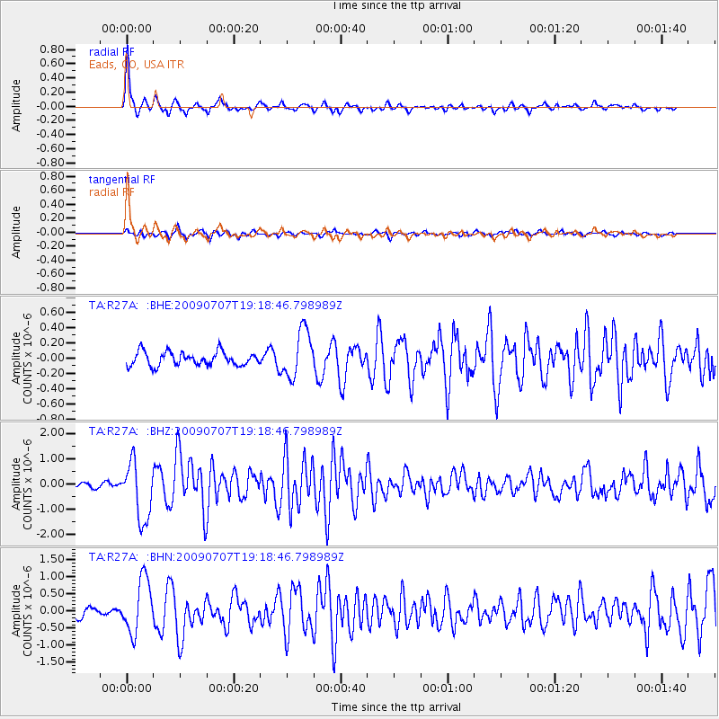
Signal To Noise
| Channel | StoN | STA | LTA |
| TA:R27A: :BHZ:20090707T19:18:46.798989Z | 10.75554 | 1.1531255E-6 | 1.0721224E-7 |
| TA:R27A: :BHN:20090707T19:18:46.798989Z | 5.8188806 | 7.927179E-7 | 1.3623203E-7 |
| TA:R27A: :BHE:20090707T19:18:46.798989Z | 3.4788592 | 3.1409752E-7 | 9.028751E-8 |
| Arrivals |
| Ps | 5.4 SECOND |
| PpPs | 17 SECOND |
| PsPs/PpSs | 23 SECOND |


