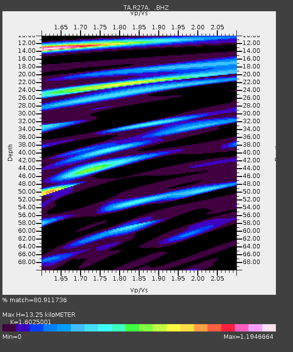
R27A Eads, CO, USA - Earthquake Result Viewer
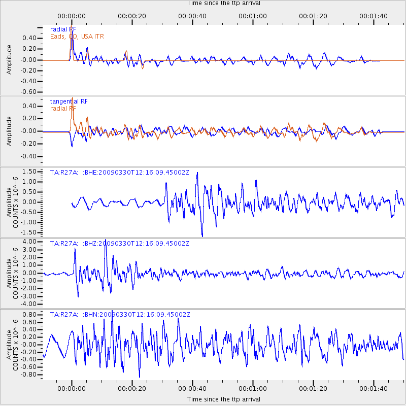
Earthquake location: Andreanof Islands, Aleutian Is.
Earthquake latitude/longitude: 51.5/-178.3
Earthquake time(UTC): 2009/03/30 (089) 12:07:28 GMT
Earthquake Depth: 31 km
Earthquake Magnitude: 6.0 MB, 5.5 MS, 5.7 MW, 5.7 MW
Earthquake Catalog/Contributor: WHDF/NEIC
Network: TA USArray Transportable Network (new EarthScope stations)
Station: R27A Eads, CO, USA
Lat/Lon: 38.29 N/102.80 W
Elevation: 1201 m
Distance: 52.8 deg
Az: 73.123 deg
Baz: 310.579 deg
Ray Param: 0.06650232
Estimated Moho Depth: 13.25 km
Estimated Crust Vp/Vs: 1.60
Assumed Crust Vp: 6.242 km/s
Estimated Crust Vs: 3.895 km/s
Estimated Crust Poisson's Ratio: 0.18
Radial Match: 80.911736 %
Radial Bump: 400
Transverse Match: 60.492653 %
Transverse Bump: 400
SOD ConfigId: 2658
Insert Time: 2010-03-06 20:06:49.295 +0000
GWidth: 2.5
Max Bumps: 400
Tol: 0.001

Signal To Noise

ChannelStoNSTALTA
TA:R27A: :BHZ:20090330T12:16:09.45002Z9.4020981.2095268E-61.2864434E-7
TA:R27A: :BHN:20090330T12:16:09.45002Z1.64778792.8526318E-71.7311886E-7
TA:R27A: :BHE:20090330T12:16:09.45002Z2.94685674.3429336E-71.4737512E-7
Arrivals
Ps1.4 SECOND
PpPs5.2 SECOND
PsPs/PpSs6.6 SECOND