You are here: Home > Network List > TA - USArray Transportable Network (new EarthScope stations) Stations List
> Station R27A Eads, CO, USA > Earthquake Result Viewer
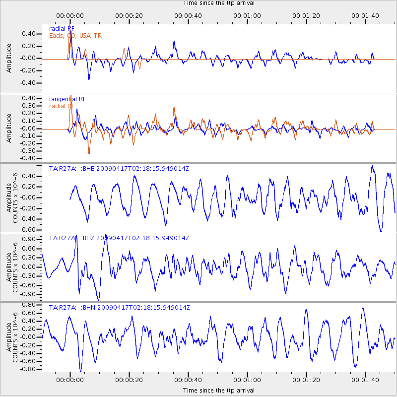
R27A Eads, CO, USA - Earthquake Result Viewer
*The percent match for this event was below the threshold and hence no stack was calculated.
| Earthquake location: |
Near Coast Of Northern Chile |
| Earthquake latitude/longitude: |
-19.6/-70.5 |
| Earthquake time(UTC): |
2009/04/17 (107) 02:08:08 GMT |
| Earthquake Depth: |
25 km |
| Earthquake Magnitude: |
5.8 MB, 5.8 MS, 6.1 MW, 6.1 MW |
| Earthquake Catalog/Contributor: |
WHDF/NEIC |
|
| Network: |
TA USArray Transportable Network (new EarthScope stations) |
| Station: |
R27A Eads, CO, USA |
| Lat/Lon: |
38.29 N/102.80 W |
| Elevation: |
1201 m |
|
| Distance: |
65.1 deg |
| Az: |
332.361 deg |
| Baz: |
146.234 deg |
| Ray Param: |
$rayparam |
*The percent match for this event was below the threshold and hence was not used in the summary stack. |
|
| Radial Match: |
68.50176 % |
| Radial Bump: |
399 |
| Transverse Match: |
58.379337 % |
| Transverse Bump: |
336 |
| SOD ConfigId: |
2658 |
| Insert Time: |
2010-03-06 20:07:02.308 +0000 |
| GWidth: |
2.5 |
| Max Bumps: |
400 |
| Tol: |
0.001 |
|
Signal To Noise
| Channel | StoN | STA | LTA |
| TA:R27A: :BHZ:20090417T02:18:15.949014Z | 1.6208586 | 4.723771E-7 | 2.9143635E-7 |
| TA:R27A: :BHN:20090417T02:18:15.949014Z | 2.064319 | 4.2445402E-7 | 2.0561457E-7 |
| TA:R27A: :BHE:20090417T02:18:15.949014Z | 1.219082 | 2.5384966E-7 | 2.0823018E-7 |
| Arrivals |
| Ps | |
| PpPs | |
| PsPs/PpSs | |


