You are here: Home > Network List > TA - USArray Transportable Network (new EarthScope stations) Stations List
> Station R27A Eads, CO, USA > Earthquake Result Viewer
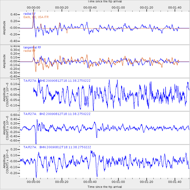
R27A Eads, CO, USA - Earthquake Result Viewer
*The percent match for this event was below the threshold and hence no stack was calculated.
| Earthquake location: |
Catamarca Province, Argentina |
| Earthquake latitude/longitude: |
-27.9/-66.7 |
| Earthquake time(UTC): |
2009/08/12 (224) 18:00:52 GMT |
| Earthquake Depth: |
174 km |
| Earthquake Magnitude: |
5.5 MW, 5.3 MB, 5.5 MW |
| Earthquake Catalog/Contributor: |
WHDF/NEIC |
|
| Network: |
TA USArray Transportable Network (new EarthScope stations) |
| Station: |
R27A Eads, CO, USA |
| Lat/Lon: |
38.29 N/102.80 W |
| Elevation: |
1201 m |
|
| Distance: |
74.0 deg |
| Az: |
331.143 deg |
| Baz: |
147.123 deg |
| Ray Param: |
$rayparam |
*The percent match for this event was below the threshold and hence was not used in the summary stack. |
|
| Radial Match: |
69.52016 % |
| Radial Bump: |
400 |
| Transverse Match: |
50.999226 % |
| Transverse Bump: |
400 |
| SOD ConfigId: |
2622 |
| Insert Time: |
2010-03-06 20:07:04.915 +0000 |
| GWidth: |
2.5 |
| Max Bumps: |
400 |
| Tol: |
0.001 |
|
Signal To Noise
| Channel | StoN | STA | LTA |
| TA:R27A: :BHZ:20090812T18:11:38.275022Z | 4.8715982 | 2.6460057E-7 | 5.431494E-8 |
| TA:R27A: :BHN:20090812T18:11:38.275022Z | 2.3004985 | 1.0567958E-7 | 4.593769E-8 |
| TA:R27A: :BHE:20090812T18:11:38.275022Z | 1.4893664 | 7.327684E-8 | 4.9200008E-8 |
| Arrivals |
| Ps | |
| PpPs | |
| PsPs/PpSs | |


