You are here: Home > Network List > TS - TERRAscope (Southern California Seismic Network) Stations List
> Station CWC Cottonwood Creek Canyon, California, USA > Earthquake Result Viewer
CWC Cottonwood Creek Canyon, California, USA - Earthquake Result Viewer

| Earthquake location: |
Near N. Coast Of Eastern Siberia |
| Earthquake latitude/longitude: |
67.0/-173.2 |
| Earthquake time(UTC): |
1996/10/24 (298) 19:31:53 GMT |
| Earthquake Depth: |
20 km |
| Earthquake Magnitude: |
6.0 MB, 5.9 MS, 6.1 UNKNOWN, 5.8 ME |
| Earthquake Catalog/Contributor: |
WHDF/NEIC |
|
| Network: |
TS TERRAscope (Southern California Seismic Network) |
| Station: |
CWC Cottonwood Creek Canyon, California, USA |
| Lat/Lon: |
36.44 N/118.08 W |
| Elevation: |
1553 m |
|
| Distance: |
43.5 deg |
| Az: |
106.113 deg |
| Baz: |
332.067 deg |
| Ray Param: |
0.07246253 |
| Estimated Moho Depth: |
34.75 km |
| Estimated Crust Vp/Vs: |
1.74 |
| Assumed Crust Vp: |
6.291 km/s |
| Estimated Crust Vs: |
3.621 km/s |
| Estimated Crust Poisson's Ratio: |
0.25 |
|
| Radial Match: |
86.095795 % |
| Radial Bump: |
400 |
| Transverse Match: |
74.71151 % |
| Transverse Bump: |
400 |
| SOD ConfigId: |
6273 |
| Insert Time: |
2010-02-26 14:05:34.516 +0000 |
| GWidth: |
2.5 |
| Max Bumps: |
400 |
| Tol: |
0.001 |
|
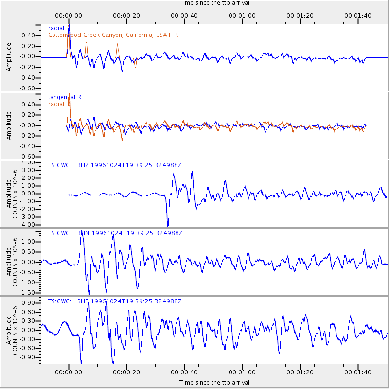
Signal To Noise
| Channel | StoN | STA | LTA |
| TS:CWC: :BHN:19961024T19:39:25.324988Z | 5.5236516 | 5.862481E-7 | 1.06134166E-7 |
| TS:CWC: :BHE:19961024T19:39:25.324988Z | 2.583736 | 3.502795E-7 | 1.3557093E-7 |
| TS:CWC: :BHZ:19961024T19:39:25.324988Z | 8.8053255 | 1.3642451E-6 | 1.549341E-7 |
| Arrivals |
| Ps | 4.3 SECOND |
| PpPs | 14 SECOND |
| PsPs/PpSs | 19 SECOND |


