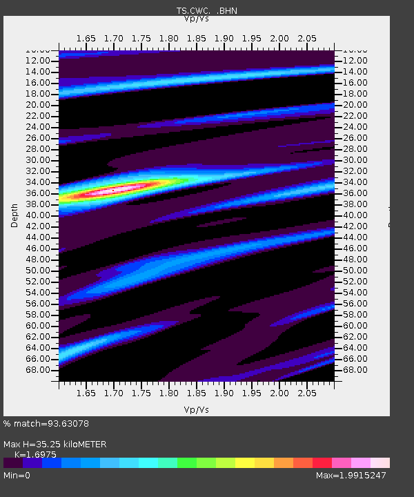
CWC Cottonwood Creek Canyon, California, USA - Earthquake Result Viewer
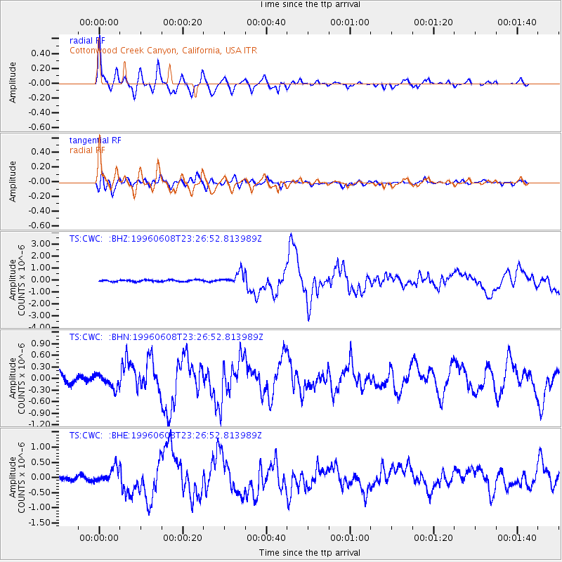
Earthquake location: Andreanof Islands, Aleutian Is.
Earthquake latitude/longitude: 51.5/-178.1
Earthquake time(UTC): 1996/06/08 (160) 23:19:15 GMT
Earthquake Depth: 33 km
Earthquake Magnitude: 5.9 MB, 6.3 MS, 6.5 UNKNOWN, 6.1 MS
Earthquake Catalog/Contributor: WHDF/NEIC
Network: TS TERRAscope (Southern California Seismic Network)
Station: CWC Cottonwood Creek Canyon, California, USA
Lat/Lon: 36.44 N/118.08 W
Elevation: 1553 m
Distance: 44.5 deg
Az: 85.457 deg
Baz: 309.387 deg
Ray Param: 0.071815744
Estimated Moho Depth: 35.25 km
Estimated Crust Vp/Vs: 1.70
Assumed Crust Vp: 6.291 km/s
Estimated Crust Vs: 3.706 km/s
Estimated Crust Poisson's Ratio: 0.23
Radial Match: 93.63078 %
Radial Bump: 400
Transverse Match: 85.075424 %
Transverse Bump: 400
SOD ConfigId: 6273
Insert Time: 2010-02-26 14:05:39.681 +0000
GWidth: 2.5
Max Bumps: 400
Tol: 0.001

Signal To Noise

ChannelStoNSTALTA
TS:CWC: :BHN:19960608T23:26:52.813989Z1.70870391.7569283E-71.0282229E-7
TS:CWC: :BHE:19960608T23:26:52.813989Z2.23635862.626437E-71.1744257E-7
TS:CWC: :BHZ:19960608T23:26:52.813989Z7.6772585.0078654E-76.522987E-8
Arrivals
Ps4.2 SECOND
PpPs14 SECOND
PsPs/PpSs18 SECOND