You are here: Home > Network List > US - United States National Seismic Network Stations List
> Station MSO Missoula, Montana, USA > Earthquake Result Viewer
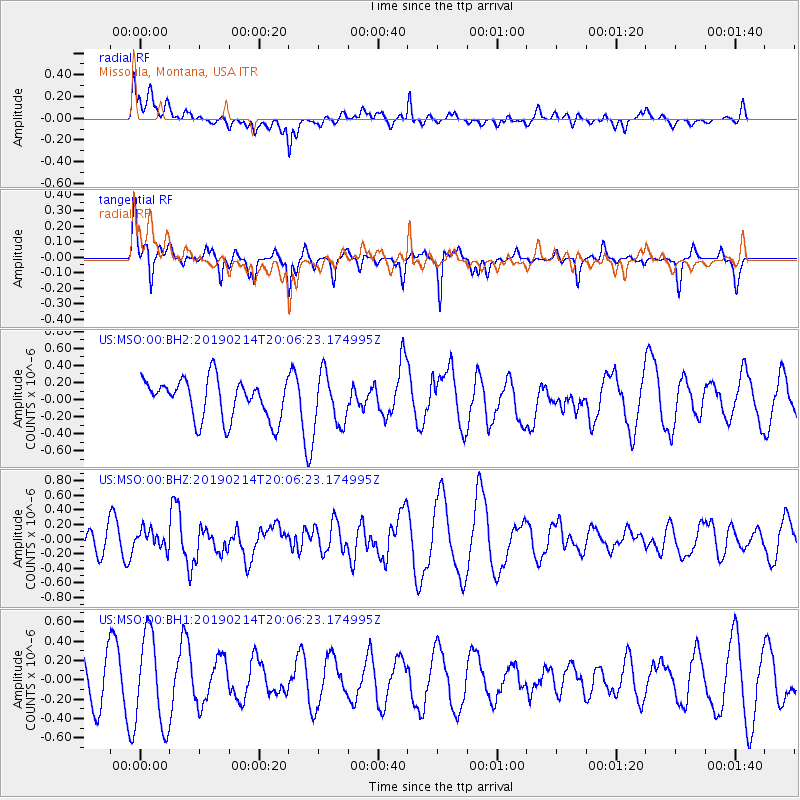
MSO Missoula, Montana, USA - Earthquake Result Viewer
*The percent match for this event was below the threshold and hence no stack was calculated.
| Earthquake location: |
Northern Mid-Atlantic Ridge |
| Earthquake latitude/longitude: |
35.4/-36.1 |
| Earthquake time(UTC): |
2019/02/14 (045) 19:57:05 GMT |
| Earthquake Depth: |
10 km |
| Earthquake Magnitude: |
6.1 Mww |
| Earthquake Catalog/Contributor: |
NEIC PDE/us |
|
| Network: |
US United States National Seismic Network |
| Station: |
MSO Missoula, Montana, USA |
| Lat/Lon: |
46.83 N/113.94 W |
| Elevation: |
1264 m |
|
| Distance: |
57.5 deg |
| Az: |
307.269 deg |
| Baz: |
71.257 deg |
| Ray Param: |
$rayparam |
*The percent match for this event was below the threshold and hence was not used in the summary stack. |
|
| Radial Match: |
35.642307 % |
| Radial Bump: |
400 |
| Transverse Match: |
66.00725 % |
| Transverse Bump: |
289 |
| SOD ConfigId: |
13570011 |
| Insert Time: |
2019-05-02 13:07:31.127 +0000 |
| GWidth: |
2.5 |
| Max Bumps: |
400 |
| Tol: |
0.001 |
|
Signal To Noise
| Channel | StoN | STA | LTA |
| US:MSO:00:BHZ:20190214T20:06:23.174995Z | 0.490833 | 1.2864473E-7 | 2.620947E-7 |
| US:MSO:00:BH1:20190214T20:06:23.174995Z | 1.7454205 | 4.7070534E-7 | 2.696802E-7 |
| US:MSO:00:BH2:20190214T20:06:23.174995Z | 1.1643434 | 2.7710993E-7 | 2.3799676E-7 |
| Arrivals |
| Ps | |
| PpPs | |
| PsPs/PpSs | |


