You are here: Home > Network List > TA - USArray Transportable Network (new EarthScope stations) Stations List
> Station L21A Rawlins, WY, USA > Earthquake Result Viewer
L21A Rawlins, WY, USA - Earthquake Result Viewer
| Earthquake location: |
Fiji Islands Region |
| Earthquake latitude/longitude: |
-17.3/-177.3 |
| Earthquake time(UTC): |
2008/07/19 (201) 22:39:52 GMT |
| Earthquake Depth: |
391 km |
| Earthquake Magnitude: |
5.9 MB, 6.4 MW, 6.4 MW |
| Earthquake Catalog/Contributor: |
WHDF/NEIC |
|
| Network: |
TA USArray Transportable Network (new EarthScope stations) |
| Station: |
L21A Rawlins, WY, USA |
| Lat/Lon: |
41.96 N/107.37 W |
| Elevation: |
2065 m |
|
| Distance: |
87.3 deg |
| Az: |
44.534 deg |
| Baz: |
243.922 deg |
| Ray Param: |
0.042405695 |
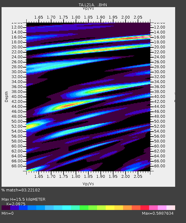
| Estimated Moho Depth: |
15.5 km |
| Estimated Crust Vp/Vs: |
2.10 |
| Assumed Crust Vp: |
6.159 km/s |
| Estimated Crust Vs: |
2.936 km/s |
| Estimated Crust Poisson's Ratio: |
0.35 |
|
| Radial Match: |
83.22182 % |
| Radial Bump: |
400 |
| Transverse Match: |
77.02323 % |
| Transverse Bump: |
400 |
| SOD ConfigId: |
2504 |
| Insert Time: |
2010-03-06 20:07:53.761 +0000 |
| GWidth: |
2.5 |
| Max Bumps: |
400 |
| Tol: |
0.001 |
|
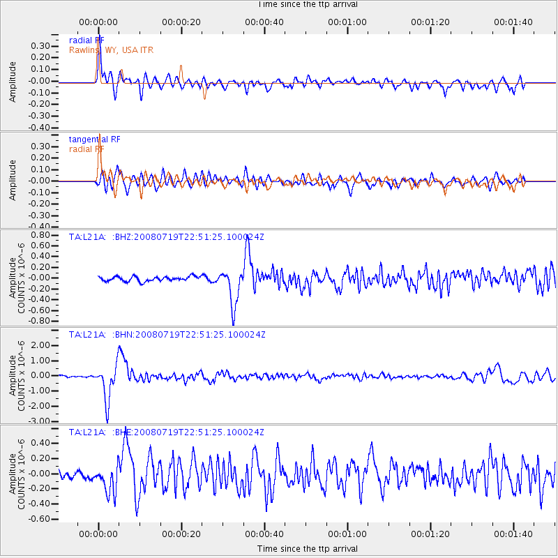
Signal To Noise
| Channel | StoN | STA | LTA |
| TA:L21A: :BHN:20080719T22:51:25.100024Z | 23.151888 | 1.2098219E-6 | 5.2255864E-8 |
| TA:L21A: :BHE:20080719T22:51:25.100024Z | 3.3690057 | 1.8846343E-7 | 5.5940372E-8 |
| TA:L21A: :BHZ:20080719T22:51:25.100024Z | 7.9427295 | 3.4512186E-7 | 4.345129E-8 |
| Arrivals |
| Ps | 2.8 SECOND |
| PpPs | 7.7 SECOND |
| PsPs/PpSs | 10 SECOND |


