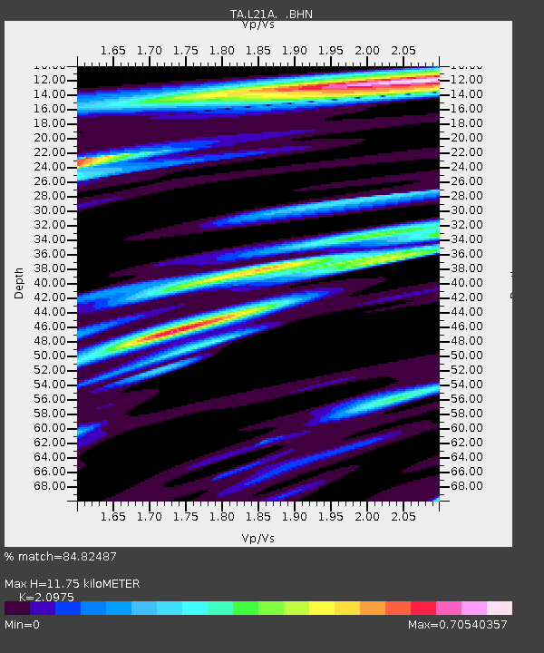
L21A Rawlins, WY, USA - Earthquake Result Viewer
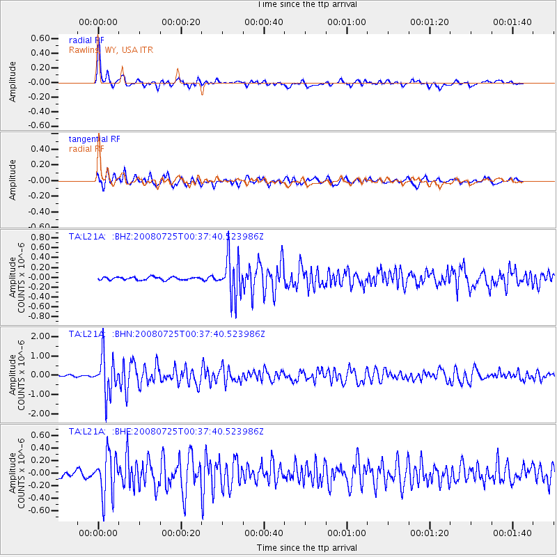
Earthquake location: Rat Islands, Aleutian Islands
Earthquake latitude/longitude: 51.3/179.0
Earthquake time(UTC): 2008/07/25 (207) 00:29:22 GMT
Earthquake Depth: 21 km
Earthquake Magnitude: 5.7 MB, 5.5 MS, 5.9 MW, 5.9 MW
Earthquake Catalog/Contributor: WHDF/NEIC
Network: TA USArray Transportable Network (new EarthScope stations)
Station: L21A Rawlins, WY, USA
Lat/Lon: 41.96 N/107.37 W
Elevation: 2065 m
Distance: 49.4 deg
Az: 70.385 deg
Baz: 307.505 deg
Ray Param: 0.06867194
Estimated Moho Depth: 11.75 km
Estimated Crust Vp/Vs: 2.10
Assumed Crust Vp: 6.159 km/s
Estimated Crust Vs: 2.936 km/s
Estimated Crust Poisson's Ratio: 0.35
Radial Match: 84.82487 %
Radial Bump: 400
Transverse Match: 81.76775 %
Transverse Bump: 400
SOD ConfigId: 2504
Insert Time: 2010-03-06 20:07:58.340 +0000
GWidth: 2.5
Max Bumps: 400
Tol: 0.001

Signal To Noise

ChannelStoNSTALTA
TA:L21A: :BHN:20080725T00:37:40.523986Z23.6231171.0023673E-64.2431626E-8
TA:L21A: :BHE:20080725T00:37:40.523986Z8.2722943.533001E-74.270884E-8
TA:L21A: :BHZ:20080725T00:37:40.523986Z13.9247524.0335834E-72.8967003E-8
Arrivals
Ps2.2 SECOND
PpPs5.6 SECOND
PsPs/PpSs7.8 SECOND