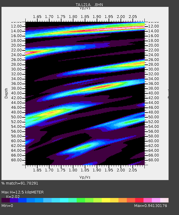
L21A Rawlins, WY, USA - Earthquake Result Viewer
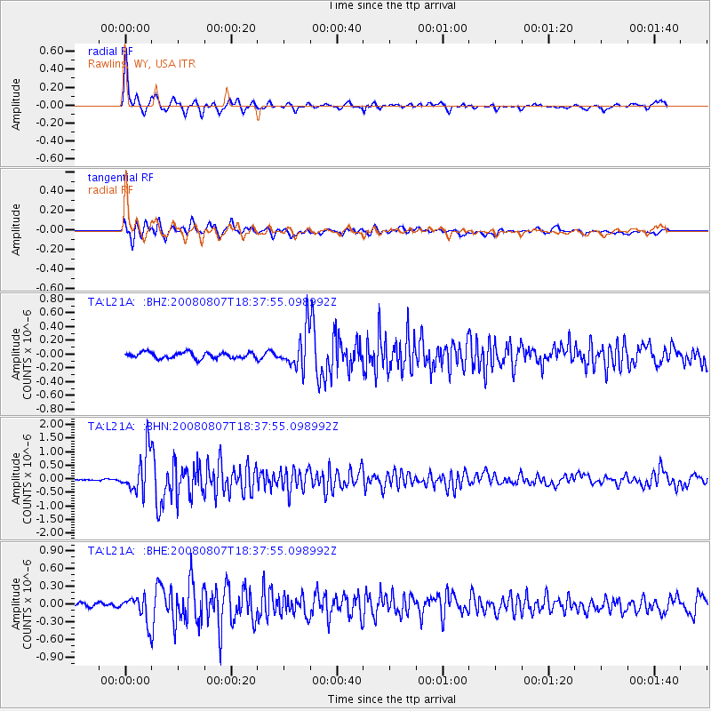
Earthquake location: Andreanof Islands, Aleutian Is.
Earthquake latitude/longitude: 52.2/-175.7
Earthquake time(UTC): 2008/08/07 (220) 18:30:03 GMT
Earthquake Depth: 12 km
Earthquake Magnitude: 5.6 MB, 5.5 MS, 5.8 MW, 5.8 MW
Earthquake Catalog/Contributor: WHDF/NEIC
Network: TA USArray Transportable Network (new EarthScope stations)
Station: L21A Rawlins, WY, USA
Lat/Lon: 41.96 N/107.37 W
Elevation: 2065 m
Distance: 46.0 deg
Az: 74.463 deg
Baz: 307.318 deg
Ray Param: 0.070921384
Estimated Moho Depth: 12.5 km
Estimated Crust Vp/Vs: 2.02
Assumed Crust Vp: 6.159 km/s
Estimated Crust Vs: 3.049 km/s
Estimated Crust Poisson's Ratio: 0.34
Radial Match: 91.78291 %
Radial Bump: 331
Transverse Match: 83.674835 %
Transverse Bump: 400
SOD ConfigId: 2504
Insert Time: 2010-03-06 20:08:02.991 +0000
GWidth: 2.5
Max Bumps: 400
Tol: 0.001

Signal To Noise

ChannelStoNSTALTA
TA:L21A: :BHN:20080807T18:37:55.098992Z17.663717.7134337E-74.3668255E-8
TA:L21A: :BHE:20080807T18:37:55.098992Z4.5227542.2340163E-74.939504E-8
TA:L21A: :BHZ:20080807T18:37:55.098992Z6.3664822.747821E-74.3160746E-8
Arrivals
Ps2.2 SECOND
PpPs5.8 SECOND
PsPs/PpSs8.0 SECOND