You are here: Home > Network List > TA - USArray Transportable Network (new EarthScope stations) Stations List
> Station L21A Rawlins, WY, USA > Earthquake Result Viewer
L21A Rawlins, WY, USA - Earthquake Result Viewer
| Earthquake location: |
Arctic Ocean |
| Earthquake latitude/longitude: |
79.8/-115.4 |
| Earthquake time(UTC): |
2008/10/07 (281) 10:00:48 GMT |
| Earthquake Depth: |
10 km |
| Earthquake Magnitude: |
5.6 MB, 5.5 MS, 5.7 MW, 5.7 MW |
| Earthquake Catalog/Contributor: |
WHDF/NEIC |
|
| Network: |
TA USArray Transportable Network (new EarthScope stations) |
| Station: |
L21A Rawlins, WY, USA |
| Lat/Lon: |
41.96 N/107.37 W |
| Elevation: |
2065 m |
|
| Distance: |
38.1 deg |
| Az: |
170.221 deg |
| Baz: |
357.677 deg |
| Ray Param: |
0.075757414 |
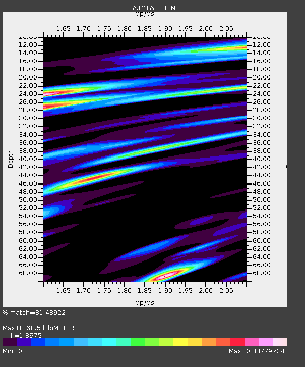
| Estimated Moho Depth: |
68.5 km |
| Estimated Crust Vp/Vs: |
1.90 |
| Assumed Crust Vp: |
6.159 km/s |
| Estimated Crust Vs: |
3.246 km/s |
| Estimated Crust Poisson's Ratio: |
0.31 |
|
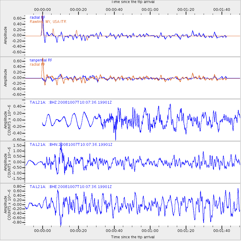
| Radial Match: |
81.48922 % |
| Radial Bump: |
400 |
| Transverse Match: |
42.756756 % |
| Transverse Bump: |
399 |
| SOD ConfigId: |
2556 |
| Insert Time: |
2010-03-06 20:08:14.311 +0000 |
| GWidth: |
2.5 |
| Max Bumps: |
400 |
| Tol: |
0.001 |
|
Signal To Noise
| Channel | StoN | STA | LTA |
| TA:L21A: :BHN:20081007T10:07:36.19901Z | 2.1799488 | 2.452652E-7 | 1.1250961E-7 |
| TA:L21A: :BHE:20081007T10:07:36.19901Z | 1.5752728 | 1.6772783E-7 | 1.06475426E-7 |
| TA:L21A: :BHZ:20081007T10:07:36.19901Z | 0.87725645 | 1.15936274E-7 | 1.321578E-7 |
| Arrivals |
| Ps | 11 SECOND |
| PpPs | 30 SECOND |
| PsPs/PpSs | 41 SECOND |


