You are here: Home > Network List > TA - USArray Transportable Network (new EarthScope stations) Stations List
> Station L21A Rawlins, WY, USA > Earthquake Result Viewer
L21A Rawlins, WY, USA - Earthquake Result Viewer
| Earthquake location: |
North Of Honduras |
| Earthquake latitude/longitude: |
17.2/-84.8 |
| Earthquake time(UTC): |
2008/03/27 (087) 09:42:57 GMT |
| Earthquake Depth: |
10 km |
| Earthquake Magnitude: |
5.6 MW, 5.1 MS, 5.4 MB, 5.6 MW |
| Earthquake Catalog/Contributor: |
WHDF/NEIC |
|
| Network: |
TA USArray Transportable Network (new EarthScope stations) |
| Station: |
L21A Rawlins, WY, USA |
| Lat/Lon: |
41.96 N/107.37 W |
| Elevation: |
2065 m |
|
| Distance: |
31.3 deg |
| Az: |
326.652 deg |
| Baz: |
135.207 deg |
| Ray Param: |
0.0790984 |
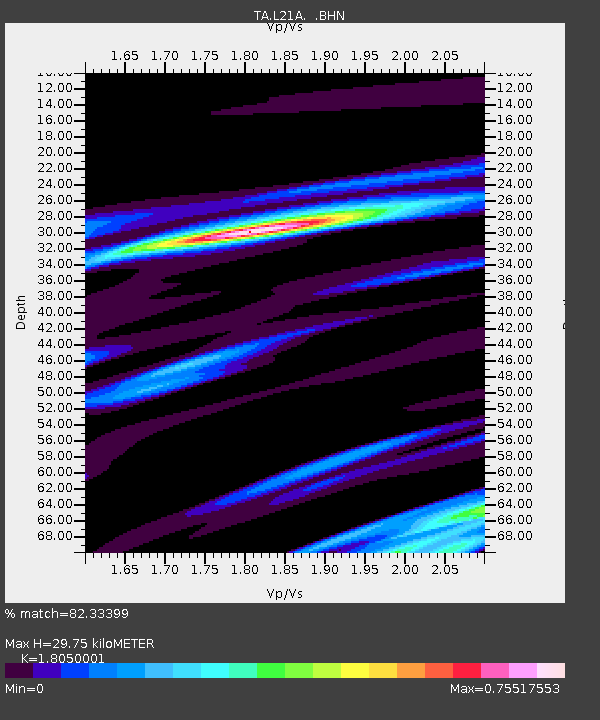
| Estimated Moho Depth: |
29.75 km |
| Estimated Crust Vp/Vs: |
1.81 |
| Assumed Crust Vp: |
6.159 km/s |
| Estimated Crust Vs: |
3.412 km/s |
| Estimated Crust Poisson's Ratio: |
0.28 |
|
| Radial Match: |
82.33399 % |
| Radial Bump: |
330 |
| Transverse Match: |
67.309525 % |
| Transverse Bump: |
400 |
| SOD ConfigId: |
2564 |
| Insert Time: |
2010-03-06 20:08:32.588 +0000 |
| GWidth: |
2.5 |
| Max Bumps: |
400 |
| Tol: |
0.001 |
|
Signal To Noise
| Channel | StoN | STA | LTA |
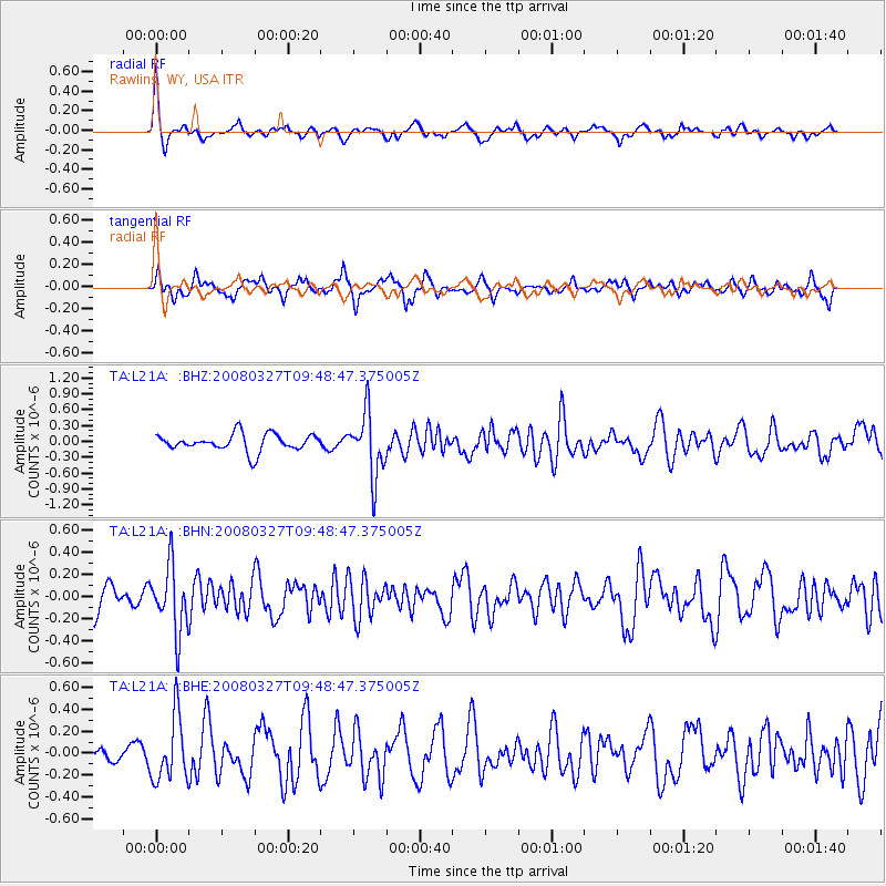
| TA:L21A: :BHN:20080327T09:48:47.375005Z | 2.273225 | 2.937447E-7 | 1.2921937E-7 |
| TA:L21A: :BHE:20080327T09:48:47.375005Z | 3.0213099 | 2.941628E-7 | 9.7362665E-8 |
| TA:L21A: :BHZ:20080327T09:48:47.375005Z | 3.6746972 | 5.944344E-7 | 1.6176419E-7 |
| Arrivals |
| Ps | 4.2 SECOND |
| PpPs | 13 SECOND |
| PsPs/PpSs | 17 SECOND |


