You are here: Home > Network List > TS - TERRAscope (Southern California Seismic Network) Stations List
> Station CWC Cottonwood Creek Canyon, California, USA > Earthquake Result Viewer
CWC Cottonwood Creek Canyon, California, USA - Earthquake Result Viewer

| Earthquake location: |
Near Coast Of Northern Chile |
| Earthquake latitude/longitude: |
-23.9/-70.1 |
| Earthquake time(UTC): |
1996/04/19 (110) 00:19:31 GMT |
| Earthquake Depth: |
50 km |
| Earthquake Magnitude: |
6.0 MB, 6.1 MS, 6.6 UNKNOWN, 6.5 ME |
| Earthquake Catalog/Contributor: |
WHDF/NEIC |
|
| Network: |
TS TERRAscope (Southern California Seismic Network) |
| Station: |
CWC Cottonwood Creek Canyon, California, USA |
| Lat/Lon: |
36.44 N/118.08 W |
| Elevation: |
1553 m |
|
| Distance: |
75.2 deg |
| Az: |
321.71 deg |
| Baz: |
135.326 deg |
| Ray Param: |
0.05172322 |
| Estimated Moho Depth: |
38.75 km |
| Estimated Crust Vp/Vs: |
1.60 |
| Assumed Crust Vp: |
6.291 km/s |
| Estimated Crust Vs: |
3.932 km/s |
| Estimated Crust Poisson's Ratio: |
0.18 |
|
| Radial Match: |
84.86635 % |
| Radial Bump: |
400 |
| Transverse Match: |
68.67789 % |
| Transverse Bump: |
400 |
| SOD ConfigId: |
6273 |
| Insert Time: |
2010-02-26 14:05:40.836 +0000 |
| GWidth: |
2.5 |
| Max Bumps: |
400 |
| Tol: |
0.001 |
|
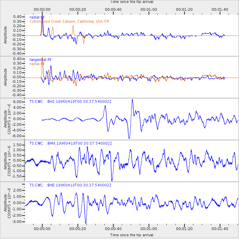
Signal To Noise
| Channel | StoN | STA | LTA |
| TS:CWC: :BHN:19960419T00:30:37.540002Z | 0.8022146 | 2.6322093E-7 | 3.2811784E-7 |
| TS:CWC: :BHE:19960419T00:30:37.540002Z | 1.9337575 | 6.005455E-7 | 3.1055885E-7 |
| TS:CWC: :BHZ:19960419T00:30:37.540002Z | 2.4563975 | 7.3560807E-7 | 2.994662E-7 |
| Arrivals |
| Ps | 3.8 SECOND |
| PpPs | 15 SECOND |
| PsPs/PpSs | 19 SECOND |


