You are here: Home > Network List > TS - TERRAscope (Southern California Seismic Network) Stations List
> Station CWC Cottonwood Creek Canyon, California, USA > Earthquake Result Viewer
CWC Cottonwood Creek Canyon, California, USA - Earthquake Result Viewer
| Earthquake location: |
South Of Fiji Islands |
| Earthquake latitude/longitude: |
-26.8/-177.2 |
| Earthquake time(UTC): |
1996/07/23 (205) 03:32:12 GMT |
| Earthquake Depth: |
33 km |
| Earthquake Magnitude: |
5.8 MB, 6.4 MS, 6.5 UNKNOWN, 6.5 MW |
| Earthquake Catalog/Contributor: |
WHDF/NEIC |
|
| Network: |
TS TERRAscope (Southern California Seismic Network) |
| Station: |
CWC Cottonwood Creek Canyon, California, USA |
| Lat/Lon: |
36.44 N/118.08 W |
| Elevation: |
1553 m |
|
| Distance: |
84.0 deg |
| Az: |
44.101 deg |
| Baz: |
230.506 deg |
| Ray Param: |
0.045775477 |
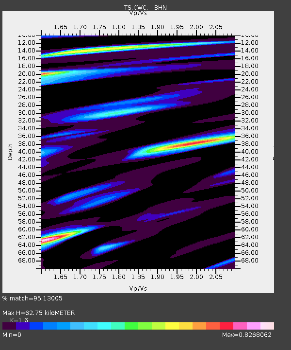
| Estimated Moho Depth: |
62.75 km |
| Estimated Crust Vp/Vs: |
1.60 |
| Assumed Crust Vp: |
6.291 km/s |
| Estimated Crust Vs: |
3.932 km/s |
| Estimated Crust Poisson's Ratio: |
0.18 |
|
| Radial Match: |
95.13005 % |
| Radial Bump: |
400 |
| Transverse Match: |
82.07425 % |
| Transverse Bump: |
400 |
| SOD ConfigId: |
6273 |
| Insert Time: |
2010-02-26 14:05:41.951 +0000 |
| GWidth: |
2.5 |
| Max Bumps: |
400 |
| Tol: |
0.001 |
|

Signal To Noise
| Channel | StoN | STA | LTA |
| TS:CWC: :BHN:19960723T03:44:08.216028Z | 0.7690892 | 7.0487616E-8 | 9.165076E-8 |
| TS:CWC: :BHE:19960723T03:44:08.216028Z | 1.0997697 | 8.0199854E-8 | 7.292422E-8 |
| TS:CWC: :BHZ:19960723T03:44:08.216028Z | 6.5999064 | 3.1822765E-7 | 4.8216993E-8 |
| Arrivals |
| Ps | 6.1 SECOND |
| PpPs | 25 SECOND |
| PsPs/PpSs | 31 SECOND |


