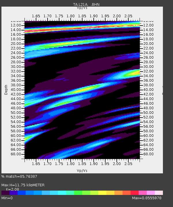
L21A Rawlins, WY, USA - Earthquake Result Viewer
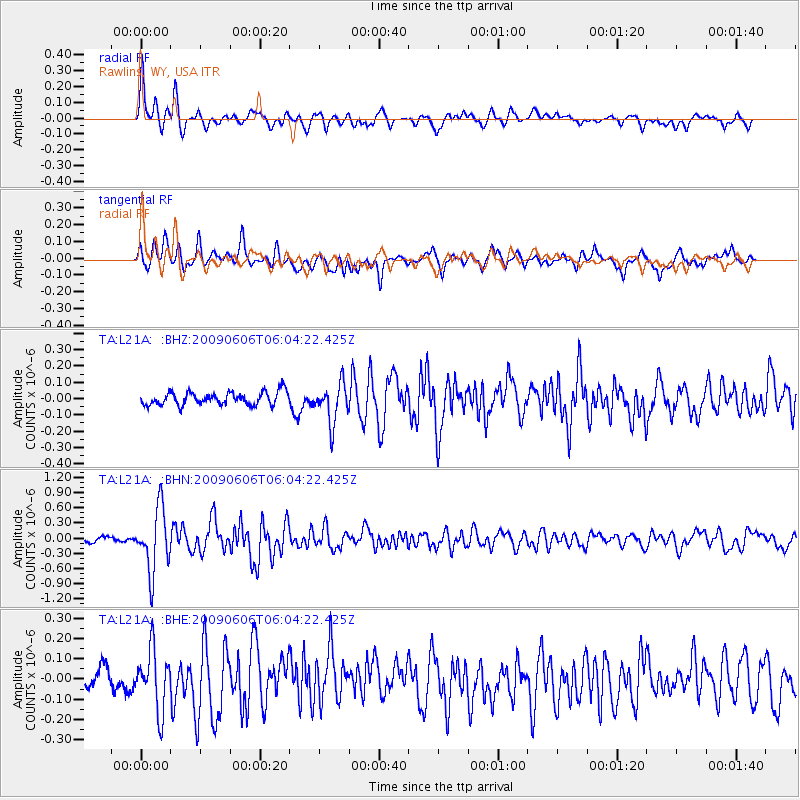
Earthquake location: Near East Coast Of Honshu, Japan
Earthquake latitude/longitude: 35.5/140.9
Earthquake time(UTC): 2009/06/06 (157) 05:52:43 GMT
Earthquake Depth: 34 km
Earthquake Magnitude: 5.8 MB, 5.4 MS, 5.8 MW, 5.7 MW
Earthquake Catalog/Contributor: WHDF/NEIC
Network: TA USArray Transportable Network (new EarthScope stations)
Station: L21A Rawlins, WY, USA
Lat/Lon: 41.96 N/107.37 W
Elevation: 2065 m
Distance: 80.8 deg
Az: 44.578 deg
Baz: 309.82 deg
Ray Param: 0.047980234
Estimated Moho Depth: 11.75 km
Estimated Crust Vp/Vs: 2.08
Assumed Crust Vp: 6.159 km/s
Estimated Crust Vs: 2.961 km/s
Estimated Crust Poisson's Ratio: 0.35
Radial Match: 85.76387 %
Radial Bump: 400
Transverse Match: 75.3079 %
Transverse Bump: 400
SOD ConfigId: 2648
Insert Time: 2010-03-06 20:09:22.247 +0000
GWidth: 2.5
Max Bumps: 400
Tol: 0.001

Signal To Noise

ChannelStoNSTALTA
TA:L21A: :BHN:20090606T06:04:22.425Z11.0896926.194448E-75.5857708E-8
TA:L21A: :BHE:20090606T06:04:22.425Z3.50520661.4775551E-74.2153157E-8
TA:L21A: :BHZ:20090606T06:04:22.425Z3.06932571.2033408E-73.9205382E-8
Arrivals
Ps2.1 SECOND
PpPs5.8 SECOND
PsPs/PpSs7.9 SECOND