You are here: Home > Network List > TA - USArray Transportable Network (new EarthScope stations) Stations List
> Station L21A Rawlins, WY, USA > Earthquake Result Viewer
L21A Rawlins, WY, USA - Earthquake Result Viewer
| Earthquake location: |
Tonga Islands Region |
| Earthquake latitude/longitude: |
-23.0/-174.7 |
| Earthquake time(UTC): |
2009/03/19 (078) 18:17:40 GMT |
| Earthquake Depth: |
34 km |
| Earthquake Magnitude: |
7.0 MB, 7.6 MS, 7.6 MW, 7.6 MW |
| Earthquake Catalog/Contributor: |
WHDF/NEIC |
|
| Network: |
TA USArray Transportable Network (new EarthScope stations) |
| Station: |
L21A Rawlins, WY, USA |
| Lat/Lon: |
41.96 N/107.37 W |
| Elevation: |
2065 m |
|
| Distance: |
89.7 deg |
| Az: |
43.47 deg |
| Baz: |
238.182 deg |
| Ray Param: |
0.041724626 |
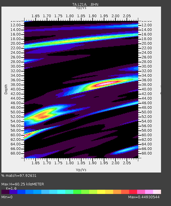
| Estimated Moho Depth: |
60.25 km |
| Estimated Crust Vp/Vs: |
1.60 |
| Assumed Crust Vp: |
6.159 km/s |
| Estimated Crust Vs: |
3.849 km/s |
| Estimated Crust Poisson's Ratio: |
0.18 |
|
| Radial Match: |
97.92631 % |
| Radial Bump: |
389 |
| Transverse Match: |
85.78009 % |
| Transverse Bump: |
400 |
| SOD ConfigId: |
2658 |
| Insert Time: |
2010-03-06 20:09:39.750 +0000 |
| GWidth: |
2.5 |
| Max Bumps: |
400 |
| Tol: |
0.001 |
|
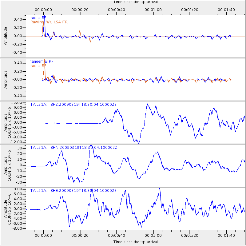
Signal To Noise
| Channel | StoN | STA | LTA |
| TA:L21A: :BHN:20090319T18:30:04.100002Z | 15.171384 | 4.019696E-6 | 2.649525E-7 |
| TA:L21A: :BHE:20090319T18:30:04.100002Z | 6.4089985 | 7.769714E-7 | 1.2123132E-7 |
| TA:L21A: :BHZ:20090319T18:30:04.100002Z | 10.714422 | 1.3344659E-6 | 1.2454856E-7 |
| Arrivals |
| Ps | 6.0 SECOND |
| PpPs | 25 SECOND |
| PsPs/PpSs | 31 SECOND |


