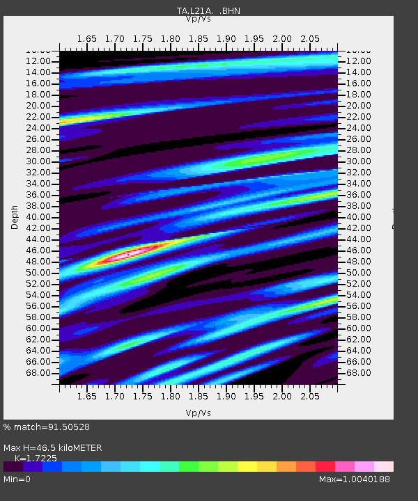
L21A Rawlins, WY, USA - Earthquake Result Viewer

Earthquake location: Rat Islands, Aleutian Islands
Earthquake latitude/longitude: 50.4/177.0
Earthquake time(UTC): 2009/07/06 (187) 14:53:12 GMT
Earthquake Depth: 22 km
Earthquake Magnitude: 6.0 MB, 5.8 MS, 6.1 MW, 6.0 MW
Earthquake Catalog/Contributor: WHDF/NEIC
Network: TA USArray Transportable Network (new EarthScope stations)
Station: L21A Rawlins, WY, USA
Lat/Lon: 41.96 N/107.37 W
Elevation: 2065 m
Distance: 50.9 deg
Az: 68.555 deg
Baz: 307.051 deg
Ray Param: 0.06771024
Estimated Moho Depth: 46.5 km
Estimated Crust Vp/Vs: 1.72
Assumed Crust Vp: 6.159 km/s
Estimated Crust Vs: 3.575 km/s
Estimated Crust Poisson's Ratio: 0.25
Radial Match: 91.50528 %
Radial Bump: 368
Transverse Match: 87.60475 %
Transverse Bump: 400
SOD ConfigId: 2648
Insert Time: 2010-03-06 20:09:41.220 +0000
GWidth: 2.5
Max Bumps: 400
Tol: 0.001

Signal To Noise

ChannelStoNSTALTA
TA:L21A: :BHN:20090706T15:01:40.824015Z6.4718012.2284814E-63.4433714E-7
TA:L21A: :BHE:20090706T15:01:40.824015Z2.78149847.099246E-72.5523101E-7
TA:L21A: :BHZ:20090706T15:01:40.824015Z4.16534668.754994E-72.1018646E-7
Arrivals
Ps5.8 SECOND
PpPs19 SECOND
PsPs/PpSs25 SECOND