You are here: Home > Network List > BK - Berkeley Digital Seismograph Network Stations List
> Station HUMO Hull Mountain, OR > Earthquake Result Viewer
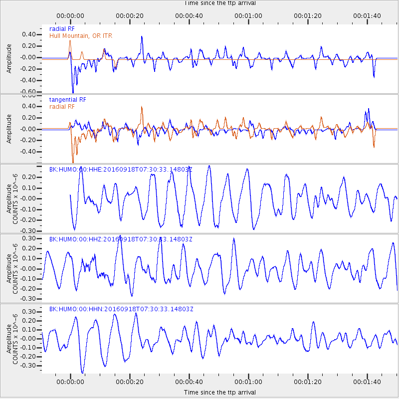
HUMO Hull Mountain, OR - Earthquake Result Viewer
*The percent match for this event was below the threshold and hence no stack was calculated.
| Earthquake location: |
Near North Coast Of Irian Jaya |
| Earthquake latitude/longitude: |
-2.0/140.5 |
| Earthquake time(UTC): |
2016/09/18 (262) 07:17:36 GMT |
| Earthquake Depth: |
10 km |
| Earthquake Magnitude: |
5.5 MB |
| Earthquake Catalog/Contributor: |
NEIC PDE/NEIC COMCAT |
|
| Network: |
BK Berkeley Digital Seismograph Network |
| Station: |
HUMO Hull Mountain, OR |
| Lat/Lon: |
42.61 N/122.96 W |
| Elevation: |
555 m |
|
| Distance: |
96.2 deg |
| Az: |
47.539 deg |
| Baz: |
272.959 deg |
| Ray Param: |
$rayparam |
*The percent match for this event was below the threshold and hence was not used in the summary stack. |
|
| Radial Match: |
72.79945 % |
| Radial Bump: |
386 |
| Transverse Match: |
56.063923 % |
| Transverse Bump: |
367 |
| SOD ConfigId: |
1634031 |
| Insert Time: |
2016-10-02 07:17:48.643 +0000 |
| GWidth: |
2.5 |
| Max Bumps: |
400 |
| Tol: |
0.001 |
|
Signal To Noise
| Channel | StoN | STA | LTA |
| BK:HUMO:00:HHZ:20160918T07:30:33.14803Z | 1.0148565 | 1.2056107E-7 | 1.1879618E-7 |
| BK:HUMO:00:HHN:20160918T07:30:33.14803Z | 2.7710948 | 2.0573763E-7 | 7.424418E-8 |
| BK:HUMO:00:HHE:20160918T07:30:33.14803Z | 1.658729 | 1.9195353E-7 | 1.1572326E-7 |
| Arrivals |
| Ps | |
| PpPs | |
| PsPs/PpSs | |


