You are here: Home > Network List > TA - USArray Transportable Network (new EarthScope stations) Stations List
> Station L21A Rawlins, WY, USA > Earthquake Result Viewer
L21A Rawlins, WY, USA - Earthquake Result Viewer
| Earthquake location: |
South Of Fiji Islands |
| Earthquake latitude/longitude: |
-26.0/-177.5 |
| Earthquake time(UTC): |
2007/12/09 (343) 07:28:20 GMT |
| Earthquake Depth: |
152 km |
| Earthquake Magnitude: |
7.0 MB, 7.8 MW, 7.7 MW |
| Earthquake Catalog/Contributor: |
WHDF/NEIC |
|
| Network: |
TA USArray Transportable Network (new EarthScope stations) |
| Station: |
L21A Rawlins, WY, USA |
| Lat/Lon: |
41.96 N/107.37 W |
| Elevation: |
2065 m |
|
| Distance: |
93.6 deg |
| Az: |
44.654 deg |
| Baz: |
238.009 deg |
| Ray Param: |
0.04114013 |
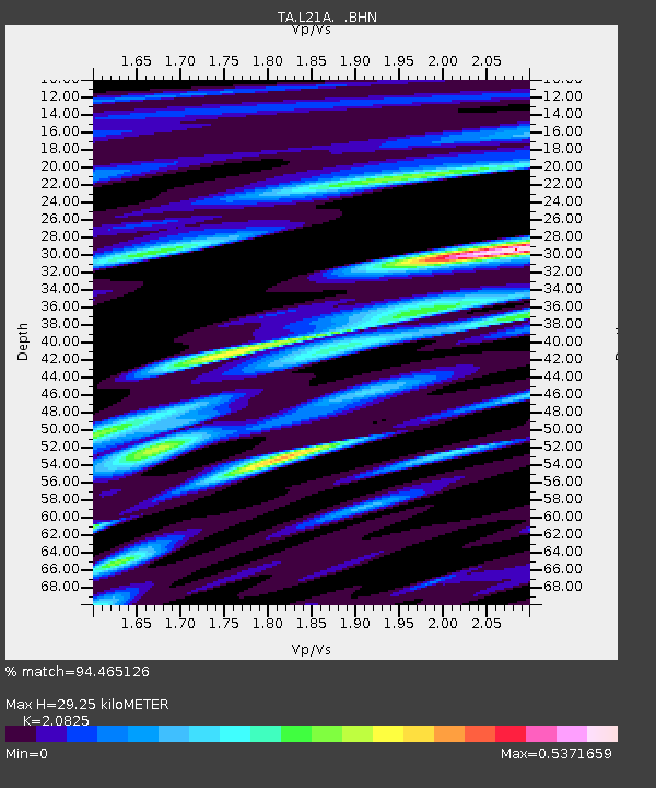
| Estimated Moho Depth: |
29.25 km |
| Estimated Crust Vp/Vs: |
2.08 |
| Assumed Crust Vp: |
6.159 km/s |
| Estimated Crust Vs: |
2.957 km/s |
| Estimated Crust Poisson's Ratio: |
0.35 |
|
| Radial Match: |
94.465126 % |
| Radial Bump: |
400 |
| Transverse Match: |
86.78469 % |
| Transverse Bump: |
400 |
| SOD ConfigId: |
2564 |
| Insert Time: |
2010-03-06 20:09:51.797 +0000 |
| GWidth: |
2.5 |
| Max Bumps: |
400 |
| Tol: |
0.001 |
|

Signal To Noise
| Channel | StoN | STA | LTA |
| TA:L21A: :BHN:20071209T07:40:48.249016Z | 1.6952549 | 1.6260789E-7 | 9.591943E-8 |
| TA:L21A: :BHE:20071209T07:40:48.249016Z | 2.1755335 | 2.9000333E-7 | 1.3330217E-7 |
| TA:L21A: :BHZ:20071209T07:40:48.249016Z | 4.439658 | 6.953625E-7 | 1.5662522E-7 |
| Arrivals |
| Ps | 5.2 SECOND |
| PpPs | 14 SECOND |
| PsPs/PpSs | 20 SECOND |


