You are here: Home > Network List > TA - USArray Transportable Network (new EarthScope stations) Stations List
> Station L21A Rawlins, WY, USA > Earthquake Result Viewer
L21A Rawlins, WY, USA - Earthquake Result Viewer
| Earthquake location: |
Off Coast Of Ecuador |
| Earthquake latitude/longitude: |
1.4/-85.2 |
| Earthquake time(UTC): |
2009/05/10 (130) 01:16:06 GMT |
| Earthquake Depth: |
6.0 km |
| Earthquake Magnitude: |
5.5 MB, 5.7 MS, 6.1 MW, 6.1 MW |
| Earthquake Catalog/Contributor: |
WHDF/NEIC |
|
| Network: |
TA USArray Transportable Network (new EarthScope stations) |
| Station: |
L21A Rawlins, WY, USA |
| Lat/Lon: |
41.96 N/107.37 W |
| Elevation: |
2065 m |
|
| Distance: |
45.1 deg |
| Az: |
336.539 deg |
| Baz: |
147.747 deg |
| Ray Param: |
0.07153977 |
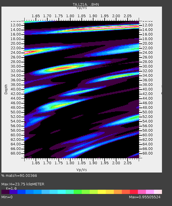
| Estimated Moho Depth: |
23.75 km |
| Estimated Crust Vp/Vs: |
1.60 |
| Assumed Crust Vp: |
6.159 km/s |
| Estimated Crust Vs: |
3.849 km/s |
| Estimated Crust Poisson's Ratio: |
0.18 |
|
| Radial Match: |
90.00366 % |
| Radial Bump: |
364 |
| Transverse Match: |
78.19533 % |
| Transverse Bump: |
400 |
| SOD ConfigId: |
2760 |
| Insert Time: |
2010-03-06 20:10:10.621 +0000 |
| GWidth: |
2.5 |
| Max Bumps: |
400 |
| Tol: |
0.001 |
|

Signal To Noise
| Channel | StoN | STA | LTA |
| TA:L21A: :BHN:20090510T01:23:52.600015Z | 7.3479867 | 4.7367183E-7 | 6.44628E-8 |
| TA:L21A: :BHE:20090510T01:23:52.600015Z | 4.2014866 | 2.7942224E-7 | 6.6505564E-8 |
| TA:L21A: :BHZ:20090510T01:23:52.600015Z | 4.3715587 | 1.890995E-7 | 4.325677E-8 |
| Arrivals |
| Ps | 2.5 SECOND |
| PpPs | 9.4 SECOND |
| PsPs/PpSs | 12 SECOND |


