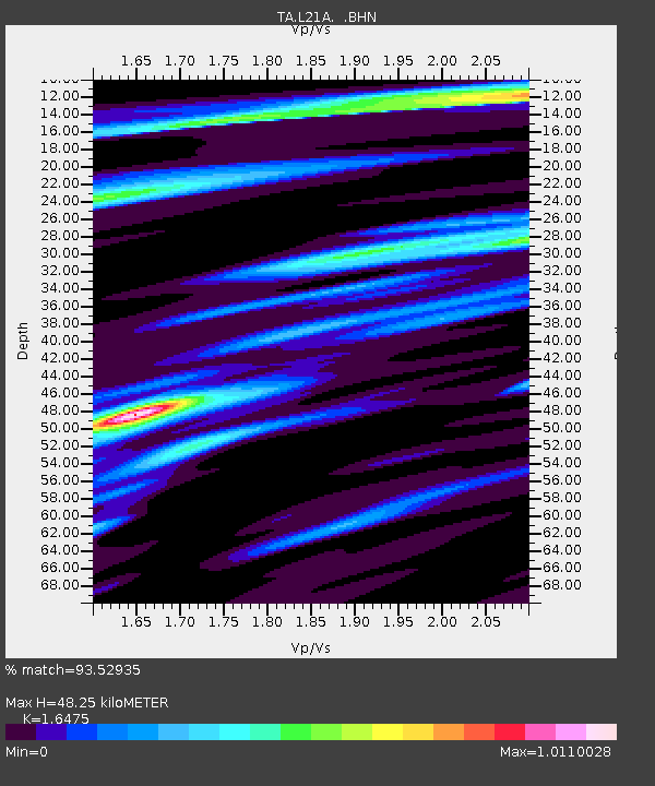
L21A Rawlins, WY, USA - Earthquake Result Viewer
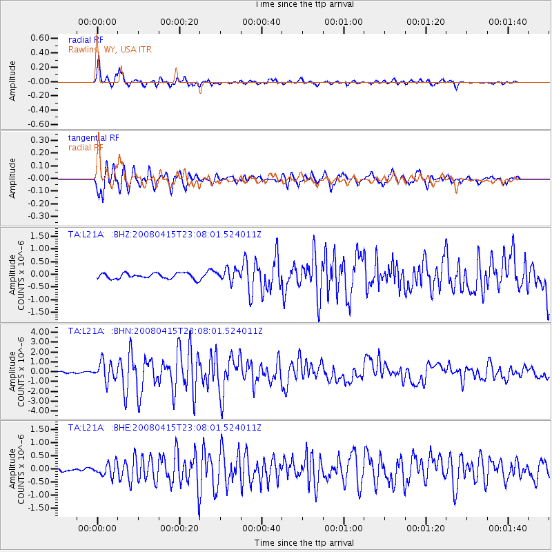
Earthquake location: Andreanof Islands, Aleutian Is.
Earthquake latitude/longitude: 51.9/-179.4
Earthquake time(UTC): 2008/04/15 (106) 22:59:51 GMT
Earthquake Depth: 10 km
Earthquake Magnitude: 6.1 MB, 6.4 MS, 6.4 MW, 6.4 MW
Earthquake Catalog/Contributor: WHDF/NEIC
Network: TA USArray Transportable Network (new EarthScope stations)
Station: L21A Rawlins, WY, USA
Lat/Lon: 41.96 N/107.37 W
Elevation: 2065 m
Distance: 48.3 deg
Az: 71.865 deg
Baz: 307.783 deg
Ray Param: 0.06946674
Estimated Moho Depth: 48.25 km
Estimated Crust Vp/Vs: 1.65
Assumed Crust Vp: 6.159 km/s
Estimated Crust Vs: 3.738 km/s
Estimated Crust Poisson's Ratio: 0.21
Radial Match: 93.52935 %
Radial Bump: 399
Transverse Match: 91.63133 %
Transverse Bump: 400
SOD ConfigId: 2504
Insert Time: 2010-03-06 20:10:15.830 +0000
GWidth: 2.5
Max Bumps: 400
Tol: 0.001

Signal To Noise

ChannelStoNSTALTA
TA:L21A: :BHN:20080415T23:08:01.524011Z10.1358869.783652E-79.652488E-8
TA:L21A: :BHE:20080415T23:08:01.524011Z3.8108962.4922002E-76.5396705E-8
TA:L21A: :BHZ:20080415T23:08:01.524011Z2.14743232.3525729E-71.09552836E-7
Arrivals
Ps5.4 SECOND
PpPs20 SECOND
PsPs/PpSs25 SECOND