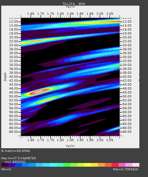
L21A Rawlins, WY, USA - Earthquake Result Viewer
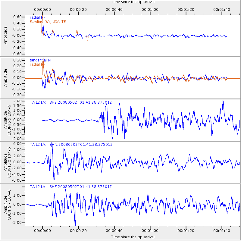
Earthquake location: Andreanof Islands, Aleutian Is.
Earthquake latitude/longitude: 51.9/-177.5
Earthquake time(UTC): 2008/05/02 (123) 01:33:37 GMT
Earthquake Depth: 14 km
Earthquake Magnitude: 6.3 MB, 6.8 MS, 6.6 MW, 6.6 MW
Earthquake Catalog/Contributor: WHDF/NEIC
Network: TA USArray Transportable Network (new EarthScope stations)
Station: L21A Rawlins, WY, USA
Lat/Lon: 41.96 N/107.37 W
Elevation: 2065 m
Distance: 47.2 deg
Az: 72.998 deg
Baz: 307.333 deg
Ray Param: 0.07014608
Estimated Moho Depth: 47.5 km
Estimated Crust Vp/Vs: 1.69
Assumed Crust Vp: 6.159 km/s
Estimated Crust Vs: 3.655 km/s
Estimated Crust Poisson's Ratio: 0.23
Radial Match: 90.9596 %
Radial Bump: 400
Transverse Match: 88.27326 %
Transverse Bump: 400
SOD ConfigId: 2504
Insert Time: 2010-03-06 20:10:18.261 +0000
GWidth: 2.5
Max Bumps: 400
Tol: 0.001

Signal To Noise

ChannelStoNSTALTA
TA:L21A: :BHN:20080502T01:41:38.37501Z15.577861.4948325E-69.595878E-8
TA:L21A: :BHE:20080502T01:41:38.37501Z1.37094651.0232714E-77.463977E-8
TA:L21A: :BHZ:20080502T01:41:38.37501Z6.80982834.65063E-76.829291E-8
Arrivals
Ps5.6 SECOND
PpPs20 SECOND
PsPs/PpSs25 SECOND