You are here: Home > Network List > TA - USArray Transportable Network (new EarthScope stations) Stations List
> Station L21A Rawlins, WY, USA > Earthquake Result Viewer
L21A Rawlins, WY, USA - Earthquake Result Viewer
| Earthquake location: |
South Of Panama |
| Earthquake latitude/longitude: |
5.0/-82.7 |
| Earthquake time(UTC): |
2008/06/17 (169) 17:42:09 GMT |
| Earthquake Depth: |
10 km |
| Earthquake Magnitude: |
5.6 MB, 5.3 MS, 5.9 MW, 5.9 MW |
| Earthquake Catalog/Contributor: |
WHDF/NEIC |
|
| Network: |
TA USArray Transportable Network (new EarthScope stations) |
| Station: |
L21A Rawlins, WY, USA |
| Lat/Lon: |
41.96 N/107.37 W |
| Elevation: |
2065 m |
|
| Distance: |
42.9 deg |
| Az: |
332.728 deg |
| Baz: |
142.26 deg |
| Ray Param: |
0.07290226 |
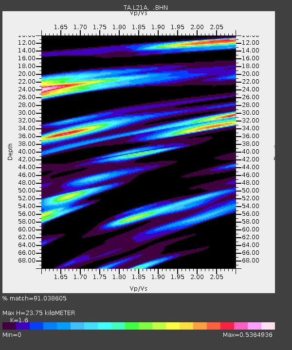
| Estimated Moho Depth: |
23.75 km |
| Estimated Crust Vp/Vs: |
1.60 |
| Assumed Crust Vp: |
6.159 km/s |
| Estimated Crust Vs: |
3.849 km/s |
| Estimated Crust Poisson's Ratio: |
0.18 |
|
| Radial Match: |
91.038605 % |
| Radial Bump: |
371 |
| Transverse Match: |
74.938965 % |
| Transverse Bump: |
400 |
| SOD ConfigId: |
2504 |
| Insert Time: |
2010-03-06 20:10:26.404 +0000 |
| GWidth: |
2.5 |
| Max Bumps: |
400 |
| Tol: |
0.001 |
|
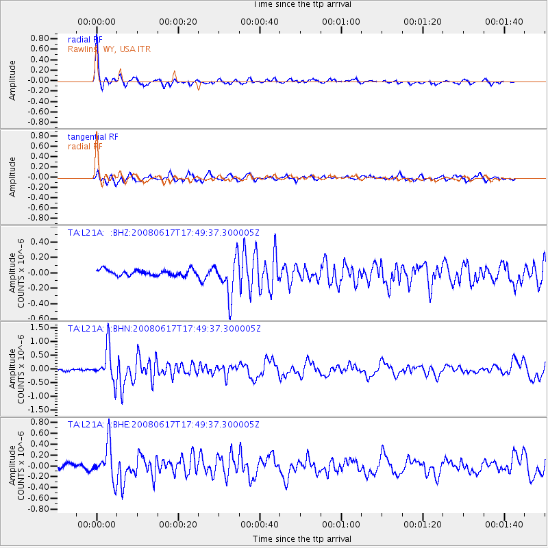
Signal To Noise
| Channel | StoN | STA | LTA |
| TA:L21A: :BHN:20080617T17:49:37.300005Z | 10.285961 | 6.428077E-7 | 6.249369E-8 |
| TA:L21A: :BHE:20080617T17:49:37.300005Z | 5.72304 | 3.4454607E-7 | 6.020333E-8 |
| TA:L21A: :BHZ:20080617T17:49:37.300005Z | 6.730485 | 2.5260232E-7 | 3.7531073E-8 |
| Arrivals |
| Ps | 2.5 SECOND |
| PpPs | 9.4 SECOND |
| PsPs/PpSs | 12 SECOND |


