You are here: Home > Network List > TA - USArray Transportable Network (new EarthScope stations) Stations List
> Station L21A Rawlins, WY, USA > Earthquake Result Viewer
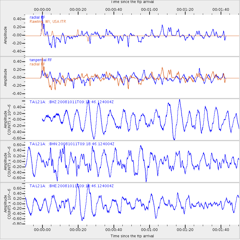
L21A Rawlins, WY, USA - Earthquake Result Viewer
*The percent match for this event was below the threshold and hence no stack was calculated.
| Earthquake location: |
Eastern Caucasus |
| Earthquake latitude/longitude: |
43.4/46.3 |
| Earthquake time(UTC): |
2008/10/11 (285) 09:06:10 GMT |
| Earthquake Depth: |
16 km |
| Earthquake Magnitude: |
5.6 MB, 5.5 MS, 5.8 MW, 5.7 MW |
| Earthquake Catalog/Contributor: |
WHDF/NEIC |
|
| Network: |
TA USArray Transportable Network (new EarthScope stations) |
| Station: |
L21A Rawlins, WY, USA |
| Lat/Lon: |
41.96 N/107.37 W |
| Elevation: |
2065 m |
|
| Distance: |
91.8 deg |
| Az: |
340.64 deg |
| Baz: |
18.912 deg |
| Ray Param: |
$rayparam |
*The percent match for this event was below the threshold and hence was not used in the summary stack. |
|
| Radial Match: |
54.384804 % |
| Radial Bump: |
400 |
| Transverse Match: |
46.99041 % |
| Transverse Bump: |
400 |
| SOD ConfigId: |
2556 |
| Insert Time: |
2010-03-06 20:10:37.940 +0000 |
| GWidth: |
2.5 |
| Max Bumps: |
400 |
| Tol: |
0.001 |
|
Signal To Noise
| Channel | StoN | STA | LTA |
| TA:L21A: :BHN:20081011T09:18:46.124004Z | 0.62757593 | 1.685405E-7 | 2.6855793E-7 |
| TA:L21A: :BHE:20081011T09:18:46.124004Z | 0.5789198 | 1.8941681E-7 | 3.2719004E-7 |
| TA:L21A: :BHZ:20081011T09:18:46.124004Z | 2.1571844 | 3.8736215E-7 | 1.7956839E-7 |
| Arrivals |
| Ps | |
| PpPs | |
| PsPs/PpSs | |


